La Condamine night lights from space
Night Light of La Condamine from space (Monaco) Src. Average luminocity for 10x10km area is 38.2939% and for 50x50km: 16.3636%.
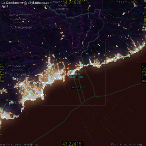
Analysis of La Condamine night lights 2016
Square area 10x10 km:
 6.52%
6.52%90-99
8.03%80-89
3.18%70-79
3.48%60-69
6.67%50-59
3.64%40-49
2.58%30-39
2.42%20-29
25.3%10-19
26.67%0-9
11.52%Square area 50x50 km:
2.92%90-99
3.49%80-89
1.37%70-79
1.81%60-69
2.44%50-59
2.26%40-49
1.64%30-39
1.74%20-29
4.87%10-19
10.96%0-9
66.51%Clear (daylight) street map image can be seen on geolist.org.
Map coordinates:
44° 14' 25" North, 6° 43' 1.6" East
43° 44' 3.8" North, 7° 25' 12.9" East
43° 13' 27.1" North, 8° 7' 24.1" East
Some cities around La Condamine sort by population:
• Monaco
0.3 km =0.2 mi,  247°
247°
• Menton, FR
8.2 km =5.1 mi,  55°
55°
• Monte-Carlo
0.8 km =0.5 mi,  43°
43°
• Beausoleil, FR
1 km =0.6 mi,  10°
10°
• Roquebrune-Cap-Martin, FR
6 km =3.7 mi, 56°
• La Trinité, FR
8.6 km =5.3 mi,  274°
274°
• Villefranche-sur-Mer, FR
9.4 km =5.8 mi, 248°
• Contes, FR
12.2 km =7.6 mi,  315°
315°
3009937 (p: 12,167)
Sources (retrieved 2019-11-25):
» Earth at Night: Flat Maps 2012, 2016