Ronchin night lights from space
Night Light of Ronchin (Hauts-de-France) from space (France) Src. Average luminocity for 10x10km area is 89.7981% and for 50x50km: 50.6787%.
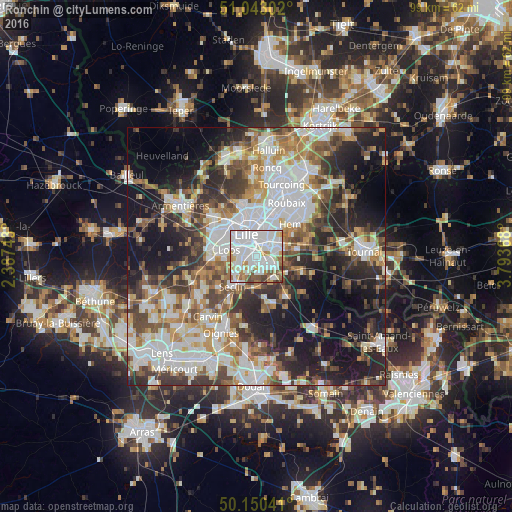
Analysis of Ronchin night lights 2016
Square area 10x10 km:
 47.06%
90-99
26.34%80-89
4.68%70-79
5.88%60-69
6.68%50-59
4.28%40-49
3.21%30-39
1.87%20-29
0%10-19
0%0-9
0%Square area 50x50 km:
13.31%90-99
10.89%80-89
4.14%70-79
5.6%60-69
6.66%50-59
6.42%40-49
7.18%30-39
7.66%20-29
11.32%10-19
16.42%0-9
10.41%Clear (daylight) street map image can be seen on geolist.org.
Map coordinates:
51° 2' 34.9" North, 2° 23' 14.7" East
50° 35' 55.8" North, 3° 5' 26" East
50° 9' 1.5" North, 3° 47' 37.2" East
Some cities around Ronchin sort by population:
• Lille
4.4 km =2.7 mi,  329°
329°
• Villeneuve-d'Ascq
5.7 km =3.5 mi,  69°
69°
• La Madeleine
5.3 km =3.3 mi,  348°
348°
• Mons-en-Barœul
4.3 km =2.7 mi,  25°
25°
• Loos
5.2 km =3.2 mi,  283°
283°
• Faches-Thumesnil
2.4 km =1.5 mi,  224°
224°
• Wattignies
3.6 km =2.2 mi,  247°
247°
• Lesquin
2.7 km =1.7 mi,  132°
132°
2982944 (p: 18,331)
Sources (retrieved 2019-11-25):
» Earth at Night: Flat Maps 2012, 2016