Loos night lights from space
Night Light of Loos (Hauts-de-France) from space (France) Src. Average luminocity for 10x10km area is 90.3543% and for 50x50km: 50.3516%.

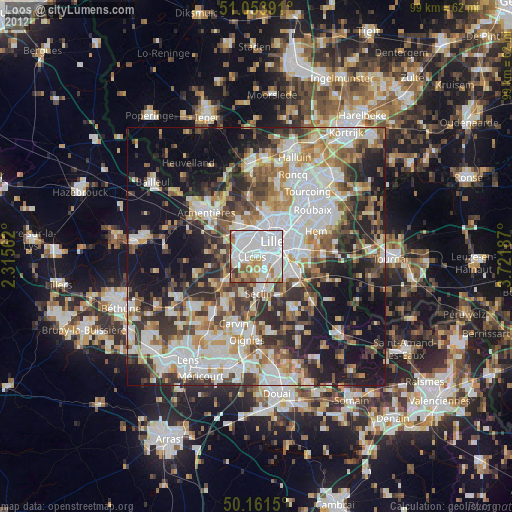
Analysis of Loos night lights 2016
Square area 10x10 km:
 48.53%
90-99
24.47%80-89
4.01%70-79
5.75%60-69
8.96%50-59
5.61%40-49
2.41%30-39
0.27%20-29
0%10-19
0%0-9
0%Square area 50x50 km:
13.29%90-99
10.99%80-89
4.25%70-79
5.72%60-69
6.54%50-59
6.34%40-49
7.07%30-39
6.97%20-29
10.23%10-19
16.74%0-9
11.86%Clear (daylight) street map image can be seen on geolist.org.
Map coordinates:
51° 3' 14.1" North, 2° 18' 56.2" East
50° 36' 35.4" North, 3° 1' 7.5" East
50° 9' 41.4" North, 3° 43' 18.7" East
Some cities around Loos sort by population:
• Lille
3.8 km =2.4 mi,  47°
47°
• Lomme
4.4 km =2.7 mi,  329°
329°
• Lambersart
4.6 km =2.9 mi,  12°
12°
• Ronchin
5.2 km =3.2 mi,  103°
103°
• Faches-Thumesnil
4.5 km =2.8 mi,  131°
131°
• Haubourdin
1.9 km =1.2 mi,  264°
264°
• Wattignies
3.2 km =2 mi,  145°
145°
• Santes
4.4 km =2.7 mi,  244°
244°
2997620 (p: 22,107)
Sources (retrieved 2019-11-25):
» Earth at Night: Flat Maps 2012, 2016