La Madeleine night lights from space
Night Light of La Madeleine (Hauts-de-France) from space (France) Src. Average luminocity for 10x10km area is 95.9626% and for 50x50km: 48.8574%.

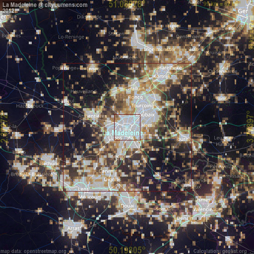
Analysis of La Madeleine night lights 2016
Square area 10x10 km:
 68.05%
90-99
21.12%80-89
2.01%70-79
3.07%60-69
1.6%50-59
2.81%40-49
0.94%30-39
0.4%20-29
0%10-19
0%0-9
0%Square area 50x50 km:
12.31%90-99
9.85%80-89
4.28%70-79
5.95%60-69
6.71%50-59
6.67%40-49
6.99%30-39
6.86%20-29
10.64%10-19
16.69%0-9
13.04%Clear (daylight) street map image can be seen on geolist.org.
Map coordinates:
51° 5' 23.2" North, 2° 22' 21.8" East
50° 38' 45.7" North, 3° 4' 33.1" East
50° 11' 53" North, 3° 46' 44.3" East
Some cities around La Madeleine sort by population:
• Lille
1.9 km =1.2 mi,  219°
219°
• Marcq-en-Barœul
2.4 km =1.5 mi,  12°
12°
• Lambersart
3 km =1.9 mi,  278°
278°
• Mons-en-Barœul
3.2 km =2 mi,  116°
116°
• Wasquehal
4.9 km =3 mi,  56°
56°
• Saint-André-lez-Lille
2.9 km =1.8 mi,  321°
321°
• Marquette-lez-Lille
3.4 km =2.1 mi,  348°
348°
• Wambrechies
4.5 km =2.8 mi,  334°
334°
3008379 (p: 23,572)
Sources (retrieved 2019-11-25):
» Earth at Night: Flat Maps 2012, 2016