Lesquin night lights from space
Night Light of Lesquin (Hauts-de-France) from space (France) Src. Average luminocity for 10x10km area is 74.1217% and for 50x50km: 50.6527%.
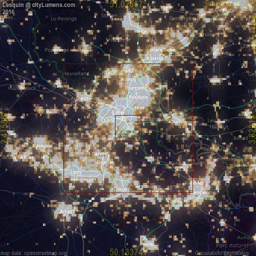
Analysis of Lesquin night lights 2016
Square area 10x10 km:
 26.74%
90-99
20.45%80-89
2.94%70-79
6.95%60-69
9.22%50-59
8.82%40-49
10.7%30-39
9.36%20-29
4.81%10-19
0%0-9
0%Square area 50x50 km:
12.99%90-99
10.81%80-89
4.2%70-79
5.53%60-69
6.79%50-59
6.42%40-49
7.14%30-39
8.09%20-29
12.34%10-19
15.88%0-9
9.8%Clear (daylight) street map image can be seen on geolist.org.
Map coordinates:
51° 1' 36" North, 2° 24' 57.2" East
50° 34' 56.4" North, 3° 7' 8.4" East
50° 8' 1.5" North, 3° 49' 19.7" East
Some cities around Lesquin sort by population:
• Lille
7.1 km =4.4 mi,  322°
322°
• Villeneuve-d'Ascq
5.1 km =3.2 mi,  41°
41°
• Mons-en-Barœul
5.7 km =3.5 mi,  358°
358°
• Loos
7.7 km =4.8 mi,  293°
293°
• Ronchin
2.7 km =1.7 mi,  312°
312°
• Faches-Thumesnil
3.7 km =2.3 mi,  271°
271°
• Wattignies
5.3 km =3.3 mi, 274°
• Seclin
7.5 km =4.7 mi,  240°
240°
2999838 (p: 6,424)
Sources (retrieved 2019-11-25):
» Earth at Night: Flat Maps 2012, 2016