Roanne night lights from space
Night Light of Roanne (Auvergne-Rhône-Alpes) from space (France) Src. Average luminocity for 10x10km area is 40.8821% and for 50x50km: 3.7322%.
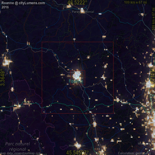

Analysis of Roanne night lights 2016
Square area 10x10 km:
 12.78%
90-99
10.8%80-89
0.57%70-79
2.13%60-69
2.84%50-59
4.12%40-49
2.27%30-39
6.25%20-29
10.51%10-19
33.95%0-9
13.78%Square area 50x50 km:
0.63%90-99
0.69%80-89
0.17%70-79
0.21%60-69
0.36%50-59
0.52%40-49
0.66%30-39
0.6%20-29
0.94%10-19
2.47%0-9
92.76%Clear (daylight) street map image can be seen on geolist.org.
Map coordinates:
46° 31' 19.9" North, 3° 21' 53.6" East
46° 2' 10.5" North, 4° 4' 4.9" East
45° 32' 45.5" North, 4° 46' 16.1" East
Some cities around Roanne sort by population:
• Thiers
44.9 km =27.9 mi,  243°
243°
• Saint-François
44 km =27.3 mi,  343°
343°
• Tarare
32.2 km =20 mi,  118°
118°
• Riorges
2.1 km =1.3 mi,  293°
293°
• Feurs
35.9 km =22.3 mi,  159°
159°
• Mably
3.2 km =2 mi,  349°
349°
• Le Coteau
2.7 km =1.7 mi,  135°
135°
• Amplepuis
21.5 km =13.4 mi,  109°
109°
2983362 (p: 39,840)
Sources (retrieved 2019-11-25):
» Earth at Night: Flat Maps 2012, 2016