Mably night lights from space
Night Light of Mably (Auvergne-Rhône-Alpes) from space (France) Src. Average luminocity for 10x10km area is 38.1634% and for 50x50km: 3.6223%.
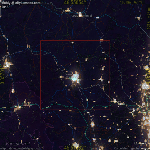
Analysis of Mably night lights 2016
Square area 10x10 km:
 12.64%
90-99
10.37%80-89
0.57%70-79
2.41%60-69
2.41%50-59
2.98%40-49
2.13%30-39
1.99%20-29
7.81%10-19
38.21%0-9
18.47%Square area 50x50 km:
0.63%90-99
0.66%80-89
0.14%70-79
0.16%60-69
0.36%50-59
0.49%40-49
0.66%30-39
0.61%20-29
0.93%10-19
2.47%0-9
92.88%Clear (daylight) street map image can be seen on geolist.org.
Map coordinates:
46° 33' 1.9" North, 3° 21' 25.2" East
46° 3' 53.4" North, 4° 3' 36.5" East
45° 34' 29.4" North, 4° 45' 47.7" East
Some cities around Mably sort by population:
• Roanne
3.2 km =2 mi,  169°
169°
• Saint-François
40.8 km =25.4 mi,  343°
343°
• Tarare
34.4 km =21.4 mi,  123°
123°
• Riorges
2.7 km =1.7 mi,  210°
210°
• Paray-le-Monial
43.5 km =27 mi,  5°
5°
• Feurs
39.1 km =24.3 mi,  160°
160°
• Le Coteau
5.7 km =3.5 mi,  153°
153°
• Amplepuis
23.2 km =14.4 mi, 116°
2996921 (p: 7,830)
Sources (retrieved 2019-11-25):
» Earth at Night: Flat Maps 2012, 2016