Tarare night lights from space
Night Light of Tarare (Auvergne-Rhône-Alpes) from space (France) Src. Average luminocity for 10x10km area is 12.3497% and for 50x50km: 9.8417%.
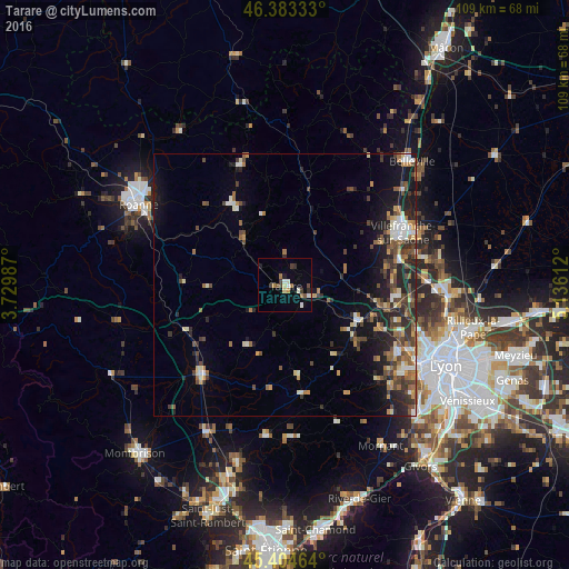
Analysis of Tarare night lights 2016
Square area 10x10 km:
 1.04%
1.04%90-99
2.53%80-89
1.49%70-79
0.74%60-69
2.23%50-59
1.04%40-49
1.79%30-39
2.38%20-29
0.74%10-19
2.23%0-9
83.78%Square area 50x50 km:
0.86%90-99
1.35%80-89
0.85%70-79
1.05%60-69
1.55%50-59
1.68%40-49
2.09%30-39
1.93%20-29
3.4%10-19
5.61%0-9
79.64%Clear (daylight) street map image can be seen on geolist.org.
Map coordinates:
46° 22' 60" North, 3° 43' 47.5" East
45° 53' 46.1" North, 4° 25' 58.8" East
45° 24' 16.7" North, 5° 8' 10" East
Some cities around Tarare sort by population:
• Villefranche-sur-Saône
24.5 km =15.2 mi,  64°
64°
• Gleizé
22.9 km =14.2 mi, 63°
• Dardilly
26.8 km =16.7 mi,  112°
112°
• Feurs
24.1 km =15 mi,  221°
221°
• Trévoux
26.7 km =16.6 mi,  78°
78°
• Amplepuis
11.6 km =7.2 mi,  316°
316°
• Anse
22.6 km =14 mi, 78°
• Lentilly
19.8 km =12.3 mi,  115°
115°
2973394 (p: 10,806)
Sources (retrieved 2019-11-25):
» Earth at Night: Flat Maps 2012, 2016