Feurs night lights from space
Night Light of Feurs (Auvergne-Rhône-Alpes) from space (France) Src. Average luminocity for 10x10km area is 9.9515% and for 50x50km: 6.512%.
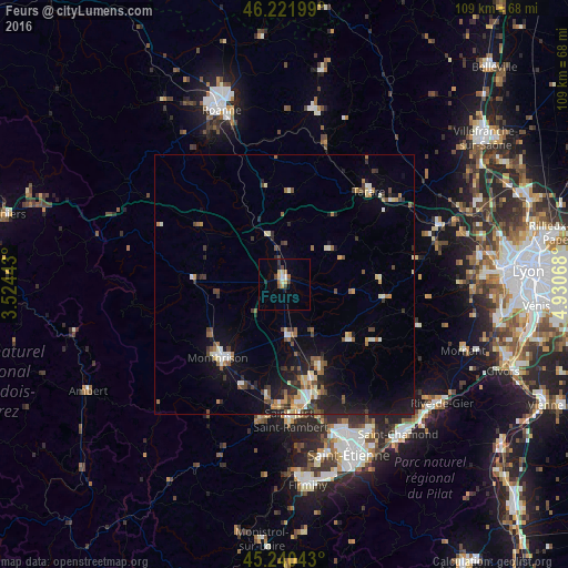
Analysis of Feurs night lights 2016
Square area 10x10 km:
 0.76%
0.76%90-99
1.52%80-89
1.36%70-79
1.52%60-69
0.91%50-59
0.61%40-49
1.97%30-39
1.97%20-29
1.52%10-19
0%0-9
87.88%Square area 50x50 km:
0.46%90-99
1.03%80-89
0.67%70-79
0.57%60-69
0.96%50-59
0.92%40-49
1.21%30-39
0.85%20-29
1.79%10-19
4.26%0-9
87.3%Clear (daylight) street map image can be seen on geolist.org.
Map coordinates:
46° 13' 19.2" North, 3° 31' 27.9" East
45° 44' 0.1" North, 4° 13' 39.2" East
45° 14' 25.5" North, 4° 55' 50.4" East
Some cities around Feurs sort by population:
• Montbrison
18.8 km =11.7 mi,  222°
222°
• Saint-Just-Saint-Rambert
26 km =16.2 mi,  177°
177°
• Tarare
24.1 km =15 mi,  41°
41°
• Andrézieux-Bouthéon
23.2 km =14.4 mi,  173°
173°
• Veauche
19.6 km =12.2 mi, 165°
• Saint-Galmier
16.4 km =10.2 mi,  156°
156°
• Amplepuis
27.8 km =17.3 mi,  16°
16°
• Sury-le-Comtal
22 km =13.7 mi,  188°
188°
3018560 (p: 7,901)
Sources (retrieved 2019-11-25):
» Earth at Night: Flat Maps 2012, 2016