Bussy-Saint-Georges night lights from space
Night Light of Bussy-Saint-Georges (Île-de-France) from space (France) Src. Average luminocity for 10x10km area is 68.5213% and for 50x50km: 46.8625%.
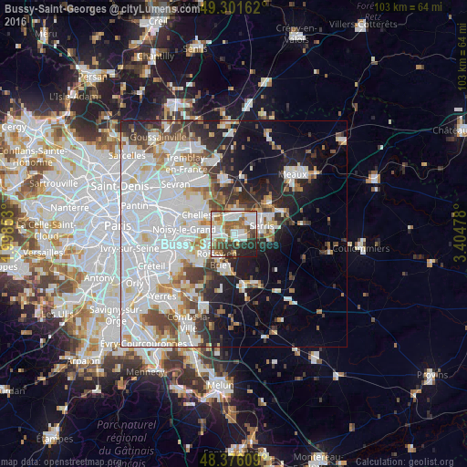
Analysis of Bussy-Saint-Georges night lights 2016
Square area 10x10 km:
 19.6%
19.6%90-99
18.89%80-89
6.25%70-79
6.25%60-69
9.09%50-59
10.09%40-49
6.53%30-39
10.09%20-29
10.65%10-19
2.56%0-9
0%Square area 50x50 km:
20.16%90-99
11.15%80-89
3.13%70-79
2.9%60-69
3.49%50-59
3.38%40-49
3.99%30-39
3.97%20-29
6.16%10-19
9.54%0-9
32.13%Clear (daylight) street map image can be seen on geolist.org.
Map coordinates:
49° 18' 5.8" North, 1° 59' 54.7" East
48° 50' 27.6" North, 2° 42' 5.9" East
48° 22' 33.9" North, 3° 24' 17.2" East
Some cities around Bussy-Saint-Georges sort by population:
• Torcy
3.9 km =2.4 mi,  286°
286°
• Lagny-sur-Marne
3.1 km =1.9 mi,  21°
21°
• Lognes
5.3 km =3.3 mi,  263°
263°
• Noisiel
5.7 km =3.5 mi,  278°
278°
• Vaires-sur-Marne
6 km =3.7 mi,  311°
311°
• Thorigny-sur-Marne
5.2 km =3.2 mi,  13°
13°
• Émerainville
6.7 km =4.2 mi,  241°
241°
• Saint-Thibault-des-Vignes
3.7 km =2.3 mi,  335°
335°
3029392 (p: 10,043)
Sources (retrieved 2019-11-25):
» Earth at Night: Flat Maps 2012, 2016