Pont-Évêque night lights from space
Night Light of Pont-Évêque (Auvergne-Rhône-Alpes) from space (France) Src. Average luminocity for 10x10km area is 31.3606% and for 50x50km: 25.1054%.
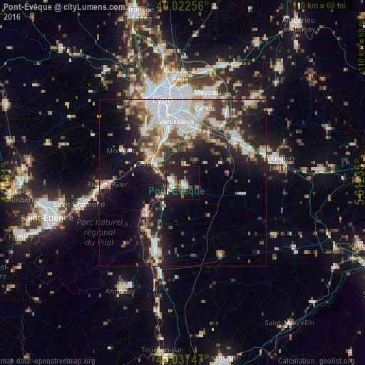
Analysis of Pont-Évêque night lights 2016
Square area 10x10 km:
 3.94%
3.94%90-99
5.91%80-89
3.33%70-79
1.97%60-69
3.03%50-59
6.21%40-49
6.06%30-39
2.12%20-29
11.97%10-19
31.67%0-9
23.79%Square area 50x50 km:
5.78%90-99
5.09%80-89
1.97%70-79
2.34%60-69
2.87%50-59
3.32%40-49
3.45%30-39
3.69%20-29
7.26%10-19
13.06%0-9
51.15%Clear (daylight) street map image can be seen on geolist.org.
Map coordinates:
46° 1' 21.2" North, 4° 12' 22" East
45° 31' 55.8" North, 4° 54' 33.2" East
45° 2' 14.9" North, 5° 36' 44.5" East
Some cities around Pont-Évêque sort by population:
• Vienne
2.8 km =1.7 mi,  254°
254°
• Givors
12.7 km =7.9 mi,  300°
300°
• Mions
14.9 km =9.3 mi,  13°
13°
• Corbas
15.1 km =9.4 mi,  357°
357°
• Feyzin
16.1 km =10 mi,  345°
345°
• Irigny
17.1 km =10.6 mi,  336°
336°
• Grigny
12.6 km =7.8 mi,  312°
312°
• Chasse-sur-Rhône
9.3 km =5.8 mi, 303°
2986191 (p: 5,479)
Sources (retrieved 2019-11-25):
» Earth at Night: Flat Maps 2012, 2016