Givors night lights from space
Night Light of Givors (Auvergne-Rhône-Alpes) from space (France) Src. Average luminocity for 10x10km area is 43.6818% and for 50x50km: 28.855%.
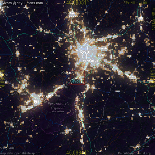
Analysis of Givors night lights 2016
Square area 10x10 km:
 4.7%
4.7%90-99
9.09%80-89
5.76%70-79
5.76%60-69
7.73%50-59
9.24%40-49
5.91%30-39
4.7%20-29
11.21%10-19
26.36%0-9
9.55%Square area 50x50 km:
7.87%90-99
6.19%80-89
2.07%70-79
2.7%60-69
3.2%50-59
3.42%40-49
3.79%30-39
4.06%20-29
6.16%10-19
12.68%0-9
47.87%Clear (daylight) street map image can be seen on geolist.org.
Map coordinates:
46° 4' 49.8" North, 4° 3' 56.4" East
45° 35' 26.3" North, 4° 46' 7.6" East
45° 5' 47.2" North, 5° 28' 18.9" East
Some cities around Givors sort by population:
• Vienne
11 km =6.8 mi,  131°
131°
• Saint-Genis-Laval
11.8 km =7.3 mi,  9°
9°
• Brignais
9.3 km =5.8 mi,  353°
353°
• Feyzin
11.5 km =7.1 mi,  37°
37°
• Irigny
10.1 km =6.3 mi,  24°
24°
• Grigny
2.6 km =1.6 mi, 39°
• Chasse-sur-Rhône
3.5 km =2.2 mi,  112°
112°
• Mornant
8.1 km =5 mi,  292°
292°
3015902 (p: 18,198)
Sources (retrieved 2019-11-25):
» Earth at Night: Flat Maps 2012, 2016