Ostwald night lights from space
Night Light of Ostwald (Grand Est) from space (France) Src. Average luminocity for 10x10km area is 79.686% and for 50x50km: 22.6548%.
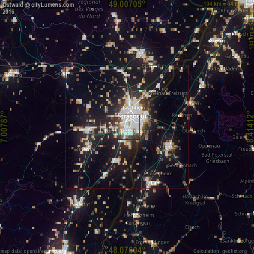
Analysis of Ostwald night lights 2016
Square area 10x10 km:
 36.01%
90-99
24.4%80-89
4.91%70-79
4.32%60-69
2.83%50-59
4.02%40-49
5.36%30-39
15.63%20-29
2.53%10-19
0%0-9
0%Square area 50x50 km:
4.84%90-99
4.48%80-89
1.72%70-79
1.65%60-69
1.9%50-59
2.08%40-49
2.45%30-39
3.53%20-29
6.06%10-19
20.29%0-9
51.01%Clear (daylight) street map image can be seen on geolist.org.
Map coordinates:
49° 0' 25.4" North, 7° 0' 28.3" East
48° 32' 37.3" North, 7° 42' 39.6" East
48° 4' 33.7" North, 8° 24' 50.8" East
Some cities around Ostwald sort by population:
• Strasbourg
5.1 km =3.2 mi,  29°
29°
• Kehl, DE
8.3 km =5.2 mi,  67°
67°
• Schiltigheim
7.6 km =4.7 mi,  21°
21°
• Illkirch-Graffenstaden
1.7 km =1.1 mi,  169°
169°
• Bischheim
8.6 km =5.3 mi, 21°
• Lingolsheim
2.6 km =1.6 mi,  306°
306°
• Geispolsheim
5.5 km =3.4 mi,  236°
236°
• Eckbolsheim
4.5 km =2.8 mi,  337°
337°
2989093 (p: 11,261)
Sources (retrieved 2019-11-25):
» Earth at Night: Flat Maps 2012, 2016