Onnaing night lights from space
Night Light of Onnaing (Hauts-de-France) from space (France) Src. Average luminocity for 10x10km area is 53.4804% and for 50x50km: 28.1095%.
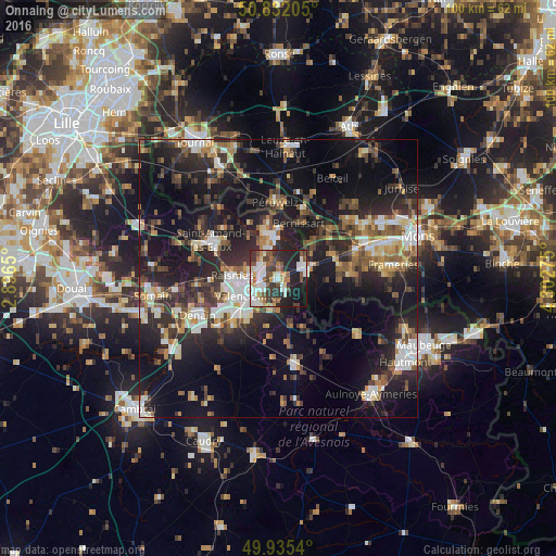
Analysis of Onnaing night lights 2016
Square area 10x10 km:
 12.04%
90-99
13.17%80-89
4.9%70-79
3.78%60-69
6.44%50-59
8.12%40-49
7%30-39
11.06%20-29
14.43%10-19
17.23%0-9
1.82%Square area 50x50 km:
3.75%90-99
4.58%80-89
2.69%70-79
2.59%60-69
3.62%50-59
4.12%40-49
4.68%30-39
5.2%20-29
11.5%10-19
21.56%0-9
35.72%Clear (daylight) street map image can be seen on geolist.org.
Map coordinates:
50° 49' 55.4" North, 2° 53' 47.4" East
50° 23' 9" North, 3° 35' 58.7" East
49° 56' 7.4" North, 4° 18' 9.9" East
Some cities around Onnaing sort by population:
• Valenciennes
6.1 km =3.8 mi,  240°
240°
• Anzin
7 km =4.3 mi,  257°
257°
• Bruay-sur-l’Escaut
4.2 km =2.6 mi,  290°
290°
• Marly
5.7 km =3.5 mi,  218°
218°
• Saint-Saulve
3.5 km =2.2 mi, 242°
• Fresnes-sur-Escaut
5.6 km =3.5 mi,  343°
343°
• Quiévrain, BE
6.4 km =4 mi,  68°
68°
• Quiévrechain
4.9 km =3 mi,  82°
82°
2989506 (p: 8,703)
Sources (retrieved 2019-11-25):
» Earth at Night: Flat Maps 2012, 2016