Valenciennes night lights from space
Night Light of Valenciennes (Hauts-de-France) from space (France) Src. Average luminocity for 10x10km area is 78.1176% and for 50x50km: 26.4019%.
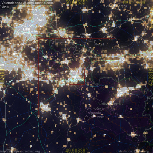

Analysis of Valenciennes night lights 2016
Square area 10x10 km:
 27.87%
90-99
24.79%80-89
9.8%70-79
6.02%60-69
4.76%50-59
6.02%40-49
4.2%30-39
9.8%20-29
5.6%10-19
1.12%0-9
0%Square area 50x50 km:
3.19%90-99
4.22%80-89
2.61%70-79
2.39%60-69
3.29%50-59
3.48%40-49
4.37%30-39
4.95%20-29
11.42%10-19
23.22%0-9
36.87%Clear (daylight) street map image can be seen on geolist.org.
Map coordinates:
50° 48' 20" North, 2° 49' 19" East
50° 21' 32.7" North, 3° 31' 30.2" East
49° 54' 30.2" North, 4° 13' 41.5" East
Some cities around Valenciennes sort by population:
• Anzin
2.1 km =1.3 mi,  313°
313°
• Raismes
4 km =2.5 mi, 312°
• Bruay-sur-l’Escaut
4.7 km =2.9 mi,  16°
16°
• Marly
2.3 km =1.4 mi,  130°
130°
• Saint-Saulve
2.6 km =1.6 mi,  58°
58°
• Aulnoy-lez-Valenciennes
2.9 km =1.8 mi,  168°
168°
• Beuvrages
3.5 km =2.2 mi,  321°
321°
• Petite-Forêt
3.1 km =1.9 mi,  285°
285°
2971041 (p: 44,821)
Sources (retrieved 2019-11-25):
» Earth at Night: Flat Maps 2012, 2016