Fresnes-sur-Escaut night lights from space
Night Light of Fresnes-sur-Escaut (Hauts-de-France) from space (France) Src. Average luminocity for 10x10km area is 47.7269% and for 50x50km: 29.1565%.
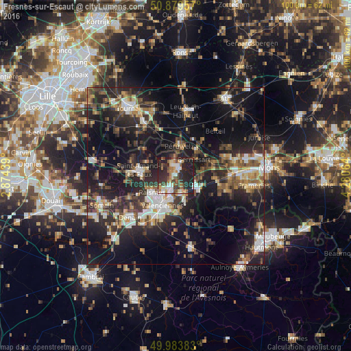
Analysis of Fresnes-sur-Escaut night lights 2016
Square area 10x10 km:
 6.16%
6.16%90-99
9.66%80-89
4.9%70-79
5.04%60-69
8.68%50-59
6.44%40-49
6.02%30-39
10.22%20-29
27.87%10-19
14.99%0-9
0%Square area 50x50 km:
3.68%90-99
4.59%80-89
2.78%70-79
2.83%60-69
3.67%50-59
4.35%40-49
5.18%30-39
5.62%20-29
12.61%10-19
22.47%0-9
32.23%Clear (daylight) street map image can be seen on geolist.org.
Map coordinates:
50° 52' 46.5" North, 2° 52' 27.8" East
50° 26' 1.8" North, 3° 34' 39.1" East
49° 59' 1.8" North, 4° 16' 50.3" East
Some cities around Fresnes-sur-Escaut sort by population:
• Bruay-sur-l’Escaut
4.5 km =2.8 mi,  211°
211°
• Bernissart, BE
6.8 km =4.2 mi,  48°
48°
• Saint-Saulve
7.1 km =4.4 mi,  192°
192°
• Vieux-Condé
2.9 km =1.8 mi,  345°
345°
• Condé-sur-l’Escaut
2.4 km =1.5 mi,  19°
19°
• Onnaing
5.6 km =3.5 mi,  163°
163°
• Hensies, BE
7.6 km =4.7 mi,  91°
91°
• Quiévrechain
7.9 km =4.9 mi,  126°
126°
3017167 (p: 7,573)
Sources (retrieved 2019-11-25):
» Earth at Night: Flat Maps 2012, 2016