Flers-en-Escrebieux night lights from space
Night Light of Flers-en-Escrebieux (Hauts-de-France) from space (France) Src. Average luminocity for 10x10km area is 80.105% and for 50x50km: 41.5625%.
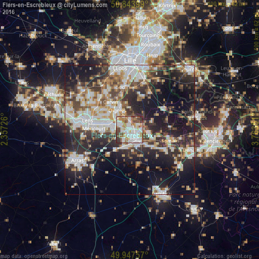
Analysis of Flers-en-Escrebieux night lights 2016
Square area 10x10 km:
 26.75%
90-99
25.91%80-89
5.88%70-79
6.02%60-69
14.29%50-59
7.42%40-49
8.26%30-39
4.9%20-29
0.56%10-19
0%0-9
0%Square area 50x50 km:
8.8%90-99
9.42%80-89
3.6%70-79
4.01%60-69
5.33%50-59
4.71%40-49
6.02%30-39
6.87%20-29
12.83%10-19
19.04%0-9
19.38%Clear (daylight) street map image can be seen on geolist.org.
Map coordinates:
50° 50' 38.4" North, 2° 21' 26.1" East
50° 23' 52.4" North, 3° 3' 37.4" East
49° 56' 51.3" North, 3° 45' 48.6" East
Some cities around Flers-en-Escrebieux sort by population:
• Douai
3.3 km =2.1 mi,  156°
156°
• Waziers
4 km =2.5 mi,  107°
107°
• Auby
1.9 km =1.2 mi,  346°
346°
• Cuincy
2.1 km =1.3 mi,  194°
194°
• Leforest
4.5 km =2.8 mi,  3°
3°
• Courcelles-lès-Lens
3.7 km =2.3 mi,  303°
303°
• Roost-Warendin
3.9 km =2.4 mi,  52°
52°
• Noyelles-Godault
5.2 km =3.2 mi,  294°
294°
3018336 (p: 5,669)
Sources (retrieved 2019-11-25):
» Earth at Night: Flat Maps 2012, 2016