Noisiel night lights from space
Night Light of Noisiel (Île-de-France) from space (France) Src. Average luminocity for 10x10km area is 84.8267% and for 50x50km: 56.7373%.
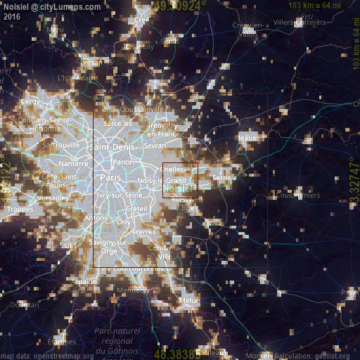
Analysis of Noisiel night lights 2016
Square area 10x10 km:
 29.83%
90-99
29.4%80-89
9.66%70-79
6.96%60-69
8.81%50-59
7.24%40-49
4.83%30-39
3.27%20-29
0%10-19
0%0-9
0%Square area 50x50 km:
27.33%90-99
12.96%80-89
3.52%70-79
3.2%60-69
3.77%50-59
3.65%40-49
4.05%30-39
4.17%20-29
6.38%10-19
10.11%0-9
20.87%Clear (daylight) street map image can be seen on geolist.org.
Map coordinates:
49° 18' 33.3" North, 1° 55' 16.4" East
48° 50' 55.2" North, 2° 37' 27.7" East
48° 23' 1.9" North, 3° 19' 38.9" East
Some cities around Noisiel sort by population:
• Noisy-le-Grand
4.5 km =2.8 mi,  271°
271°
• Chelles
4.3 km =2.7 mi,  327°
327°
• Champs-sur-Marne
1.8 km =1.1 mi, 274°
• Torcy
1.9 km =1.2 mi,  83°
83°
• Lognes
1.5 km =0.9 mi,  164°
164°
• Vaires-sur-Marne
3.3 km =2.1 mi,  20°
20°
• Émerainville
4 km =2.5 mi,  183°
183°
• Gournay-sur-Marne
3.3 km =2.1 mi,  297°
297°
2990192 (p: 15,362)
Sources (retrieved 2019-11-25):
» Earth at Night: Flat Maps 2012, 2016