Émerainville night lights from space
Night Light of Émerainville (Île-de-France) from space (France) Src. Average luminocity for 10x10km area is 82.0099% and for 50x50km: 58.5605%.
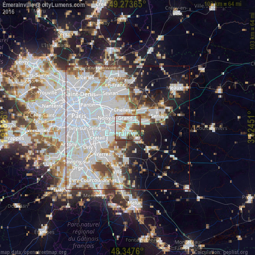
Analysis of Émerainville night lights 2016
Square area 10x10 km:
 28.27%
90-99
27.13%80-89
8.66%70-79
7.53%60-69
9.8%50-59
4.12%40-49
6.53%30-39
7.95%20-29
0%10-19
0%0-9
0%Square area 50x50 km:
28.6%90-99
13.85%80-89
3.5%70-79
3.49%60-69
3.73%50-59
3.62%40-49
4.04%30-39
3.99%20-29
5.4%10-19
8.58%0-9
21.21%Clear (daylight) street map image can be seen on geolist.org.
Map coordinates:
49° 16' 25.1" North, 1° 55' 5.7" East
48° 48' 45.9" North, 2° 37' 17" East
48° 20' 51.4" North, 3° 19' 28.2" East
Some cities around Émerainville sort by population:
• Pontault-Combault
1.9 km =1.2 mi,  213°
213°
• Champs-sur-Marne
4.4 km =2.7 mi,  339°
339°
• Torcy
4.7 km =2.9 mi,  27°
27°
• Roissy-en-Brie
3 km =1.9 mi,  140°
140°
• Le Plessis-Trévise
3.5 km =2.2 mi,  266°
266°
• Lognes
2.6 km =1.6 mi,  14°
14°
• Noisiel
4 km =2.5 mi,  3°
3°
• La Queue-en-Brie
4.3 km =2.7 mi,  223°
223°
3020247 (p: 7,002)
Sources (retrieved 2019-11-25):
» Earth at Night: Flat Maps 2012, 2016