La Bresse night lights from space
Night Light of La Bresse (Grand Est) from space (France) Src. Average luminocity for 10x10km area is 4.3736% and for 50x50km: 4.5471%.
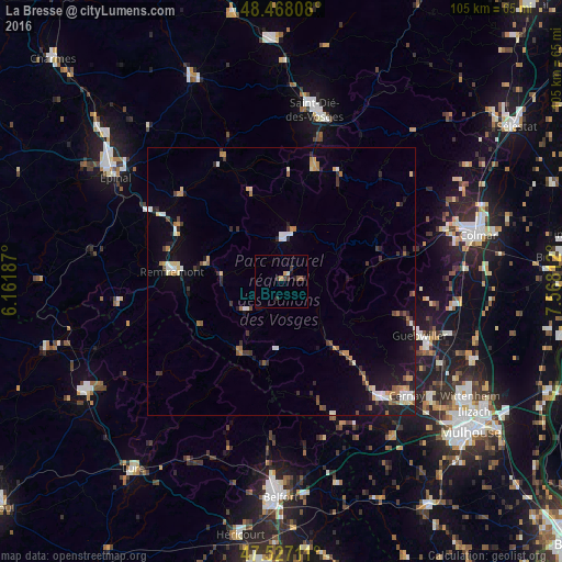
Analysis of La Bresse night lights 2016
Square area 10x10 km:
 0%
0%90-99
0.57%80-89
0%70-79
1.14%60-69
0%50-59
1.14%40-49
0.14%30-39
2.7%20-29
0.57%10-19
1.7%0-9
92.05%Square area 50x50 km:
0.49%90-99
0.66%80-89
0.43%70-79
0.57%60-69
0.7%50-59
0.41%40-49
0.47%30-39
0.85%20-29
0.89%10-19
2.98%0-9
91.55%Clear (daylight) street map image can be seen on geolist.org.
Map coordinates:
48° 28' 5.1" North, 6° 9' 42.7" East
47° 59' 59.1" North, 6° 51' 54" East
47° 31' 37.6" North, 7° 34' 5.2" East
Some cities around La Bresse sort by population:
• Saint-Dié-des-Vosges
32.2 km =20 mi,  11°
11°
• Guebwiller
26.6 km =16.5 mi,  110°
110°
• Cernay
31.4 km =19.5 mi,  132°
132°
• Gérardmer
8.3 km =5.2 mi, 6°
• Remiremont
20.7 km =12.9 mi,  275°
275°
• Thann
27.7 km =17.2 mi,  140°
140°
• Soultz-Haut-Rhin
29.8 km =18.5 mi, 114°
• Munster
20.9 km =13 mi,  77°
77°
3010815 (p: 5,096)
Sources (retrieved 2019-11-25):
» Earth at Night: Flat Maps 2012, 2016