Morteau night lights from space
Night Light of Morteau (Bourgogne-Franche-Comté) from space (France) Src. Average luminocity for 10x10km area is 13.3139% and for 50x50km: 5.1437%.
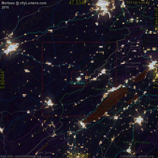
Analysis of Morteau night lights 2016
Square area 10x10 km:
 1.85%
1.85%90-99
2.27%80-89
1.28%70-79
1.7%60-69
0.57%50-59
1.85%40-49
2.27%30-39
1.85%20-29
1.14%10-19
1.7%0-9
83.52%Square area 50x50 km:
0.72%90-99
0.64%80-89
0.35%70-79
0.48%60-69
0.58%50-59
0.76%40-49
1%30-39
0.74%20-29
0.69%10-19
2.89%0-9
91.15%Clear (daylight) street map image can be seen on geolist.org.
Map coordinates:
47° 32' 4.9" North, 5° 54' 14.5" East
47° 3' 28.2" North, 6° 36' 25.8" East
46° 34' 36" North, 7° 18' 37" East
Some cities around Morteau sort by population:
• La Chaux-de-Fonds, CH
17.2 km =10.7 mi,  74°
74°
• Neuchâtel, CH
25.6 km =15.9 mi,  106°
106°
• Yverdon-les-Bains, CH
31.2 km =19.4 mi,  175°
175°
• Pontarlier
25.7 km =16 mi,  228°
228°
• Le Locle, CH
10.8 km =6.7 mi,  90°
90°
• Peseux, CH
22.8 km =14.2 mi, 110°
• Valdahon
22 km =13.7 mi,  297°
297°
• Estavayer-le-Lac, CH
29.5 km =18.3 mi,  141°
141°
2991692 (p: 6,343)
Sources (retrieved 2019-11-25):
» Earth at Night: Flat Maps 2012, 2016