Estavayer-le-Lac night lights from space
Night Light of Estavayer-le-Lac (Fribourg) from space (Switzerland) Src. Average luminocity for 10x10km area is 6.7887% and for 50x50km: 7.705%.
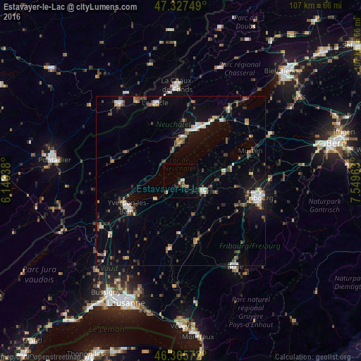
Analysis of Estavayer-le-Lac night lights 2016
Square area 10x10 km:
 0.45%
0.45%90-99
0.15%80-89
0.6%70-79
1.19%60-69
1.79%50-59
0.3%40-49
1.49%30-39
1.19%20-29
1.79%10-19
1.79%0-9
89.29%Square area 50x50 km:
0.92%90-99
0.94%80-89
0.44%70-79
0.8%60-69
0.95%50-59
1.31%40-49
1.24%30-39
1.29%20-29
1.36%10-19
4.41%0-9
86.34%Clear (daylight) street map image can be seen on geolist.org.
Map coordinates:
47° 19' 39" North, 6° 8' 36.2" East
46° 50' 55.5" North, 6° 50' 47.4" East
46° 21' 56.6" North, 7° 32' 58.7" East
Some cities around Estavayer-le-Lac sort by population:
• Fribourg
23.8 km =14.8 mi,  102°
102°
• Neuchâtel
17.1 km =10.6 mi,  21°
21°
• Yverdon-les-Bains
17.5 km =10.9 mi,  243°
243°
• Le Locle
24.2 km =15 mi,  342°
342°
• Villars-sur-Glâne
21.6 km =13.4 mi,  107°
107°
• Payerne
7.6 km =4.7 mi, 113°
• Murten/Morat
22.4 km =13.9 mi,  66°
66°
• Peseux
15.7 km =9.8 mi,  11°
11°
2660851 (p: 5,061)
Sources (retrieved 2019-11-25):
» Earth at Night: Flat Maps 2012, 2016