Valdahon night lights from space
Night Light of Valdahon (Bourgogne-Franche-Comté) from space (France) Src. Average luminocity for 10x10km area is 7.7642% and for 50x50km: 3.3989%.
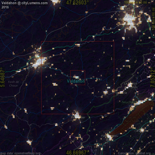
Analysis of Valdahon night lights 2016
Square area 10x10 km:
 0.99%
0.99%90-99
0.71%80-89
0.71%70-79
0.99%60-69
1.7%50-59
1.14%40-49
1.99%30-39
1.14%20-29
0.85%10-19
0.28%0-9
89.49%Square area 50x50 km:
0.37%90-99
0.4%80-89
0.21%70-79
0.55%60-69
0.39%50-59
0.46%40-49
0.55%30-39
0.59%20-29
0.76%10-19
1.89%0-9
93.82%Clear (daylight) street map image can be seen on geolist.org.
Map coordinates:
47° 37' 33.7" North, 5° 38' 48.7" East
47° 9' 0" North, 6° 21' 0" East
46° 40' 10.8" North, 7° 3' 11.2" East
Some cities around Valdahon sort by population:
• Besançon
27.4 km =17 mi,  293°
293°
• La Chaux-de-Fonds, CH
36.4 km =22.6 mi,  98°
98°
• Yverdon-les-Bains, CH
46.8 km =29.1 mi,  151°
151°
• Pontarlier
27.4 km =17 mi,  179°
179°
• Le Locle, CH
32 km =19.9 mi,  109°
109°
• Morteau
22 km =13.7 mi,  117°
117°
• Baume-les-Dames
22.6 km =14 mi,  2°
2°
• Peseux, CH
44.7 km =27.8 mi, 113°
2998998 (p: 5,077)
Sources (retrieved 2019-11-25):
» Earth at Night: Flat Maps 2012, 2016