Montpon-Ménestérol night lights from space
Night Light of Montpon-Ménestérol (Nouvelle-Aquitaine) from space (France) Src. Average luminocity for 10x10km area is 7.1571% and for 50x50km: 3.7251%.
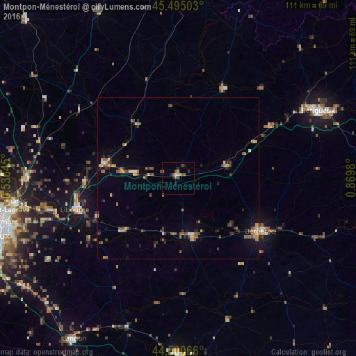
Analysis of Montpon-Ménestérol night lights 2016
Square area 10x10 km:
 0.32%
0.32%90-99
0.32%80-89
0.95%70-79
0.95%60-69
1.43%50-59
1.75%40-49
1.9%30-39
0.63%20-29
3.17%10-19
0%0-9
88.57%Square area 50x50 km:
0.14%90-99
0.27%80-89
0.3%70-79
0.57%60-69
0.78%50-59
0.68%40-49
0.91%30-39
0.53%20-29
0.88%10-19
1.13%0-9
93.81%Clear (daylight) street map image can be seen on geolist.org.
Map coordinates:
45° 29' 42.1" North, 0° 32' 11.2" West
45° 0' 0" North, 0° 10' 0" East
44° 30' 2.4" North, 0° 52' 11.3" East
Some cities around Montpon-Ménestérol sort by population:
• Périgueux
47.7 km =29.6 mi,  64°
64°
• Bergerac
29.8 km =18.5 mi,  123°
123°
• Libourne
33.7 km =20.9 mi,  253°
253°
• Ambarès-et-Lagrave
52 km =32.3 mi,  259°
259°
• Coulounieix-Chamiers
44.4 km =27.6 mi,  67°
67°
• Coutras
23.9 km =14.9 mi,  278°
278°
• Saint-Loubès
47.7 km =29.6 mi, 258°
• Boulazac
47.6 km =29.6 mi, 74°
2992132 (p: 5,658)
Sources (retrieved 2019-11-25):
» Earth at Night: Flat Maps 2012, 2016