Boulazac night lights from space
Night Light of Boulazac (Nouvelle-Aquitaine) from space (France) Src. Average luminocity for 10x10km area is 7.2288% and for 50x50km: 2.7355%.
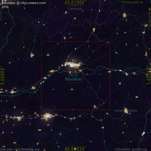
Analysis of Boulazac night lights 2016
Square area 10x10 km:
 0%
0%90-99
0.61%80-89
0%70-79
0.61%60-69
0.45%50-59
2.58%40-49
0.61%30-39
0%20-29
0.91%10-19
18.18%0-9
76.06%Square area 50x50 km:
0.31%90-99
0.37%80-89
0.23%70-79
0.26%60-69
0.39%50-59
0.51%40-49
0.41%30-39
0.4%20-29
0.55%10-19
2.42%0-9
94.14%Clear (daylight) street map image can be seen on geolist.org.
Map coordinates:
45° 36' 38.4" North, 0° 2' 48.8" East
45° 7' 0" North, 0° 45' 0" East
44° 37' 6" North, 1° 27' 11.3" East
Some cities around Boulazac sort by population:
• Périgueux
7.9 km =4.9 mi,  340°
340°
• Bergerac
36.3 km =22.6 mi,  215°
215°
• Sarlat-la-Canéda
44.6 km =27.7 mi,  124°
124°
• Coulounieix-Chamiers
6.3 km =3.9 mi,  309°
309°
• Saint-Yrieix-la-Perche
56.7 km =35.2 mi,  38°
38°
• Trélissac
9.4 km =5.8 mi,  17°
17°
• Terrasson-Lavilledieu
43.3 km =26.9 mi,  88°
88°
• Montpon-Ménestérol
47.6 km =29.6 mi,  254°
254°
3031180 (p: 6,680)
Sources (retrieved 2019-11-25):
» Earth at Night: Flat Maps 2012, 2016