Périgueux night lights from space
Night Light of Périgueux (Nouvelle-Aquitaine) from space (France) Src. Average luminocity for 10x10km area is 36.4106% and for 50x50km: 2.6585%.
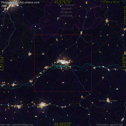

Analysis of Périgueux night lights 2016
Square area 10x10 km:
 6.97%
6.97%90-99
7.88%80-89
3.64%70-79
1.82%60-69
3.33%50-59
7.27%40-49
3.64%30-39
3.33%20-29
6.36%10-19
44.7%0-9
11.06%Square area 50x50 km:
0.31%90-99
0.36%80-89
0.21%70-79
0.26%60-69
0.38%50-59
0.52%40-49
0.37%30-39
0.37%20-29
0.55%10-19
2.39%0-9
94.28%Clear (daylight) street map image can be seen on geolist.org.
Map coordinates:
45° 40' 36.3" North, 0° 0' 48.7" East
45° 10' 60" North, 0° 43' 0" East
44° 41' 8.1" North, 1° 25' 11.2" East
Some cities around Périgueux sort by population:
• Bergerac
41.3 km =25.7 mi,  206°
206°
• Sarlat-la-Canéda
51.1 km =31.8 mi,  129°
129°
• Coulounieix-Chamiers
4 km =2.5 mi, 213°
• Saint-Yrieix-la-Perche
52.9 km =32.9 mi,  45°
45°
• Trélissac
5.7 km =3.5 mi,  73°
73°
• Boulazac
7.9 km =4.9 mi,  160°
160°
• Terrasson-Lavilledieu
46.2 km =28.7 mi,  97°
97°
• Montpon-Ménestérol
47.7 km =29.6 mi,  244°
244°
2987967 (p: 34,770)
Sources (retrieved 2019-11-25):
» Earth at Night: Flat Maps 2012, 2016