Coutras night lights from space
Night Light of Coutras (Nouvelle-Aquitaine) from space (France) Src. Average luminocity for 10x10km area is 15.5984% and for 50x50km: 7.8529%.
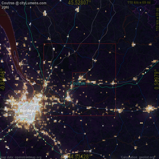
Analysis of Coutras night lights 2016
Square area 10x10 km:
 0.79%
0.79%90-99
0.48%80-89
1.11%70-79
3.17%60-69
1.43%50-59
3.49%40-49
3.49%30-39
3.02%20-29
6.19%10-19
1.9%0-9
74.92%Square area 50x50 km:
0.34%90-99
0.72%80-89
0.73%70-79
0.94%60-69
1.28%50-59
1.27%40-49
1.76%30-39
1.21%20-29
2.61%10-19
7.11%0-9
82.03%Clear (daylight) street map image can be seen on geolist.org.
Map coordinates:
45° 31' 41.1" North, 0° 50' 11.3" West
45° 1' 60" North, 0° 7' 60" West
44° 32' 3.4" North, 0° 34' 11.2" East
Some cities around Coutras sort by population:
• Libourne
15.7 km =9.8 mi,  213°
213°
• Lormont
35 km =21.7 mi,  239°
239°
• Cenon
36.2 km =22.5 mi, 236°
• Ambarès-et-Lagrave
30.4 km =18.9 mi, 244°
• Saint-Loubès
26.6 km =16.5 mi, 240°
• Bassens
33.5 km =20.8 mi, 244°
• Carbon-Blanc
32.7 km =20.3 mi, 242°
• Montpon-Ménestérol
23.9 km =14.9 mi,  98°
98°
3022799 (p: 7,682)
Sources (retrieved 2019-11-25):
» Earth at Night: Flat Maps 2012, 2016