Rillieux-la-Pape night lights from space
Night Light of Rillieux-la-Pape (Auvergne-Rhône-Alpes) from space (France) Src. Average luminocity for 10x10km area is 70.4494% and for 50x50km: 35.7255%.

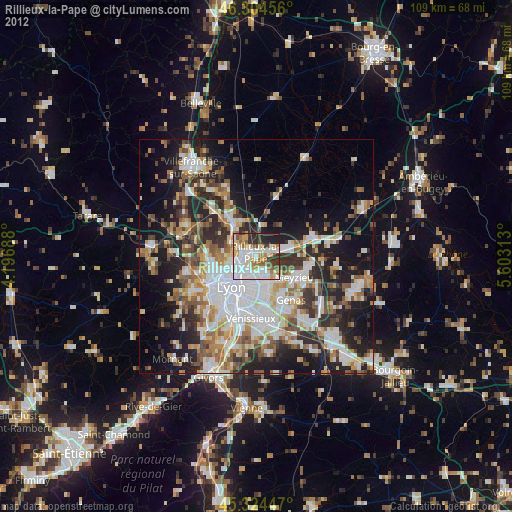
Analysis of Rillieux-la-Pape night lights 2016
Square area 10x10 km:
 23.51%
90-99
19.79%80-89
6.25%70-79
7.59%60-69
4.46%50-59
7.14%40-49
8.48%30-39
9.97%20-29
9.67%10-19
3.13%0-9
0%Square area 50x50 km:
8.97%90-99
7.23%80-89
2.75%70-79
3.67%60-69
3.97%50-59
4.69%40-49
4.94%30-39
5.99%20-29
10.99%10-19
13.38%0-9
33.42%Clear (daylight) street map image can be seen on geolist.org.
Map coordinates:
46° 18' 16.4" North, 4° 11' 48.8" East
45° 49' 0" North, 4° 54' 0" East
45° 19' 28.1" North, 5° 36' 11.3" East
Some cities around Rillieux-la-Pape sort by population:
• Lyon
8.6 km =5.3 mi,  208°
208°
• Villeurbanne
5.9 km =3.7 mi,  195°
195°
• Caluire-et-Cuire
4.8 km =3 mi,  239°
239°
• Vaulx-en-Velin
3.8 km =2.4 mi,  149°
149°
• Décines-Charpieu
7 km =4.3 mi,  139°
139°
• Miribel
4.3 km =2.7 mi,  76°
76°
• Neuville-sur-Saône
8 km =5 mi,  325°
325°
• Fontaines-sur-Saône
4.8 km =3 mi,  296°
296°
2983536 (p: 28,076)
Sources (retrieved 2019-11-25):
» Earth at Night: Flat Maps 2012, 2016