Montataire night lights from space
Night Light of Montataire (Hauts-de-France) from space (France) Src. Average luminocity for 10x10km area is 47.7928% and for 50x50km: 20.6374%.
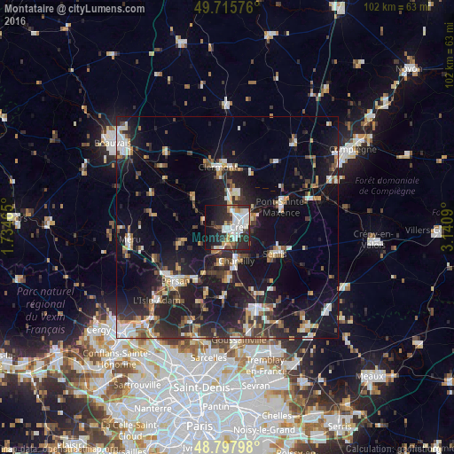
Analysis of Montataire night lights 2016
Square area 10x10 km:
 14.17%
90-99
12.03%80-89
3.48%70-79
3.21%60-69
2.67%50-59
4.01%40-49
4.01%30-39
6.95%20-29
21.79%10-19
16.98%0-9
10.7%Square area 50x50 km:
3.03%90-99
3.36%80-89
1.62%70-79
1.86%60-69
2.5%50-59
2.19%40-49
2.74%30-39
3.5%20-29
7.82%10-19
20.12%0-9
51.26%Clear (daylight) street map image can be seen on geolist.org.
Map coordinates:
49° 42' 56.7" North, 1° 44' 4.7" East
49° 15' 32.4" North, 2° 26' 16" East
48° 47' 52.7" North, 3° 8' 27.2" East
Some cities around Montataire sort by population:
• Creil
3.4 km =2.1 mi,  94°
94°
• Nogent-sur-Oise
2.8 km =1.7 mi,  59°
59°
• Chantilly
7.6 km =4.7 mi,  161°
161°
• Gouvieux
8.2 km =5.1 mi,  191°
191°
• Lamorlaye
10.8 km =6.7 mi,  176°
176°
• Liancourt
8.2 km =5.1 mi,  14°
14°
• Villers-Saint-Paul
5 km =3.1 mi,  48°
48°
• Mouy
10.6 km =6.6 mi,  306°
306°
2993004 (p: 12,031)
Sources (retrieved 2019-11-25):
» Earth at Night: Flat Maps 2012, 2016