Lamorlaye night lights from space
Night Light of Lamorlaye (Hauts-de-France) from space (France) Src. Average luminocity for 10x10km area is 32.2101% and for 50x50km: 34.1193%.
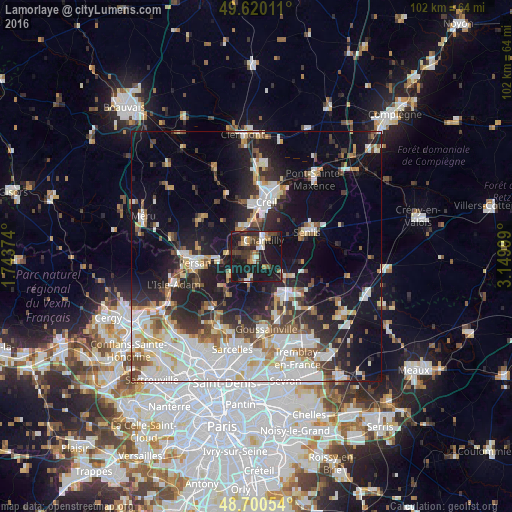
Analysis of Lamorlaye night lights 2016
Square area 10x10 km:
 2.94%
2.94%90-99
5.18%80-89
1.96%70-79
3.64%60-69
4.76%50-59
2.38%40-49
7.14%30-39
5.04%20-29
11.2%10-19
54.62%0-9
1.12%Square area 50x50 km:
9.47%90-99
7.63%80-89
2.88%70-79
2.63%60-69
3.22%50-59
3.26%40-49
3.55%30-39
4%20-29
8.13%10-19
19.2%0-9
36.03%Clear (daylight) street map image can be seen on geolist.org.
Map coordinates:
49° 37' 12.4" North, 1° 44' 37.5" East
49° 9' 44.9" North, 2° 26' 48.7" East
48° 42' 1.9" North, 3° 8' 60" East
Some cities around Lamorlaye sort by population:
• Creil
10.8 km =6.7 mi,  14°
14°
• Senlis
11.3 km =7 mi,  63°
63°
• Montataire
10.8 km =6.7 mi,  356°
356°
• Chantilly
4 km =2.5 mi,  26°
26°
• Fosses
8.5 km =5.3 mi,  147°
147°
• Gouvieux
3.6 km =2.2 mi,  319°
319°
• Beaumont-sur-Oise
11.8 km =7.3 mi,  259°
259°
• Marly-la-Ville
9.8 km =6.1 mi,  155°
155°
3008074 (p: 8,540)
Sources (retrieved 2019-11-25):
» Earth at Night: Flat Maps 2012, 2016