Chantilly night lights from space
Night Light of Chantilly (Hauts-de-France) from space (France) Src. Average luminocity for 10x10km area is 34.612% and for 50x50km: 29.4616%.
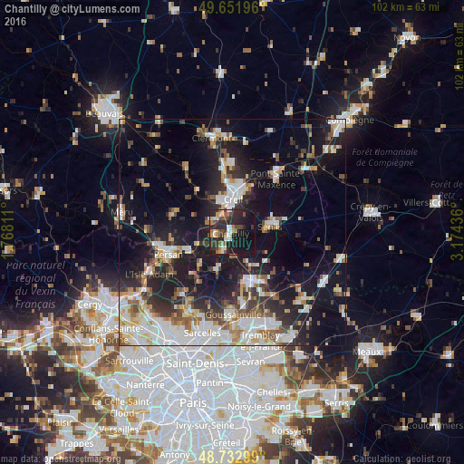
Analysis of Chantilly night lights 2016
Square area 10x10 km:
 3.5%
3.5%90-99
5.6%80-89
1.96%70-79
4.34%60-69
5.18%50-59
3.08%40-49
7.28%30-39
7%20-29
19.75%10-19
31.51%0-9
10.78%Square area 50x50 km:
6.43%90-99
6.02%80-89
2.72%70-79
2.58%60-69
3.3%50-59
3.23%40-49
3.37%30-39
3.86%20-29
8.17%10-19
19.71%0-9
40.6%Clear (daylight) street map image can be seen on geolist.org.
Map coordinates:
49° 39' 7.1" North, 1° 46' 5.2" East
49° 11' 40.6" North, 2° 28' 16.5" East
48° 43' 58.8" North, 3° 10' 27.7" East
Some cities around Chantilly sort by population:
• Creil
7 km =4.3 mi,  8°
8°
• Nogent-sur-Oise
8.6 km =5.3 mi,  359°
359°
• Senlis
8.5 km =5.3 mi,  80°
80°
• Montataire
7.6 km =4.7 mi,  341°
341°
• Fosses
11.1 km =6.9 mi,  165°
165°
• Gouvieux
4.2 km =2.6 mi,  258°
258°
• Lamorlaye
4 km =2.5 mi,  206°
206°
• Villers-Saint-Paul
10.6 km =6.6 mi, 7°
3026827 (p: 11,085)
Sources (retrieved 2019-11-25):
» Earth at Night: Flat Maps 2012, 2016