Mouy night lights from space
Night Light of Mouy (Hauts-de-France) from space (France) Src. Average luminocity for 10x10km area is 6.5201% and for 50x50km: 16.2428%.
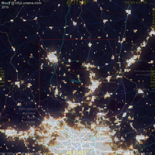
Analysis of Mouy night lights 2016
Square area 10x10 km:
 0.27%
0.27%90-99
0.27%80-89
0.53%70-79
0.67%60-69
1.07%50-59
0%40-49
2.27%30-39
1.34%20-29
0.53%10-19
4.14%0-9
88.9%Square area 50x50 km:
2.45%90-99
2.69%80-89
1.25%70-79
1.32%60-69
1.66%50-59
1.74%40-49
2.09%30-39
2.11%20-29
5.87%10-19
16.73%0-9
62.08%Clear (daylight) street map image can be seen on geolist.org.
Map coordinates:
49° 46' 17.7" North, 1° 36' 59.1" East
49° 18' 55.3" North, 2° 19' 10.3" East
48° 51' 17.5" North, 3° 1' 21.6" East
Some cities around Mouy sort by population:
• Creil
13.6 km =8.5 mi,  118°
118°
• Nogent-sur-Oise
12 km =7.5 mi,  113°
113°
• Méru
16.3 km =10.1 mi,  235°
235°
• Montataire
10.6 km =6.6 mi,  126°
126°
• Clermont
9.8 km =6.1 mi,  43°
43°
• Gouvieux
15.8 km =9.8 mi,  154°
154°
• Liancourt
10.7 km =6.6 mi,  81°
81°
• Villers-Saint-Paul
12.7 km =7.9 mi,  103°
103°
2991297 (p: 5,588)
Sources (retrieved 2019-11-25):
» Earth at Night: Flat Maps 2012, 2016