Liancourt night lights from space
Night Light of Liancourt (Hauts-de-France) from space (France) Src. Average luminocity for 10x10km area is 35.2019% and for 50x50km: 15.2334%.
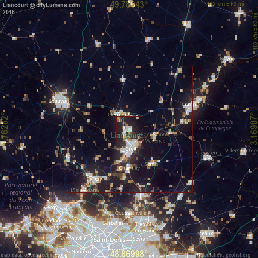
Analysis of Liancourt night lights 2016
Square area 10x10 km:
 5.21%
5.21%90-99
5.88%80-89
3.61%70-79
3.88%60-69
3.61%50-59
3.88%40-49
2.54%30-39
6.68%20-29
20.86%10-19
35.03%0-9
8.82%Square area 50x50 km:
2.12%90-99
2.4%80-89
1.2%70-79
1.34%60-69
1.8%50-59
1.73%40-49
1.91%30-39
2.02%20-29
4.96%10-19
15.13%0-9
65.38%Clear (daylight) street map image can be seen on geolist.org.
Map coordinates:
49° 47' 11.1" North, 1° 45' 46.2" East
49° 19' 49.2" North, 2° 27' 57.4" East
48° 52' 11.9" North, 3° 10' 8.7" East
Some cities around Liancourt sort by population:
• Creil
8.3 km =5.2 mi,  170°
170°
• Nogent-sur-Oise
6.5 km =4 mi,  176°
176°
• Pont-Sainte-Maxence
10.5 km =6.5 mi,  107°
107°
• Montataire
8.2 km =5.1 mi,  194°
194°
• Chantilly
15.1 km =9.4 mi, 178°
• Clermont
6.6 km =4.1 mi,  324°
324°
• Villers-Saint-Paul
4.9 km =3 mi,  159°
159°
• Mouy
10.7 km =6.6 mi,  261°
261°
2998532 (p: 6,758)
Sources (retrieved 2019-11-25):
» Earth at Night: Flat Maps 2012, 2016