Nogent-sur-Oise night lights from space
Night Light of Nogent-sur-Oise (Hauts-de-France) from space (France) Src. Average luminocity for 10x10km area is 50.4813% and for 50x50km: 18.9586%.
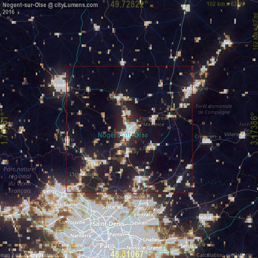
Analysis of Nogent-sur-Oise night lights 2016
Square area 10x10 km:
 13.5%
13.5%90-99
12.43%80-89
5.08%70-79
3.74%60-69
3.21%50-59
4.28%40-49
1.74%30-39
9.22%20-29
26.07%10-19
20.45%0-9
0.27%Square area 50x50 km:
2.63%90-99
2.95%80-89
1.47%70-79
1.7%60-69
2.34%50-59
2.07%40-49
2.43%30-39
2.97%20-29
7.26%10-19
19.97%0-9
54.22%Clear (daylight) street map image can be seen on geolist.org.
Map coordinates:
49° 43' 41.6" North, 1° 46' 3.4" East
49° 16' 17.7" North, 2° 28' 14.7" East
48° 48' 38.4" North, 3° 10' 25.9" East
Some cities around Nogent-sur-Oise sort by population:
• Creil
1.9 km =1.2 mi,  148°
148°
• Senlis
11 km =6.8 mi,  130°
130°
• Pont-Sainte-Maxence
10.3 km =6.4 mi,  70°
70°
• Montataire
2.8 km =1.7 mi,  239°
239°
• Chantilly
8.6 km =5.3 mi,  179°
179°
• Gouvieux
10.3 km =6.4 mi,  203°
203°
• Liancourt
6.5 km =4 mi,  356°
356°
• Villers-Saint-Paul
2.4 km =1.5 mi,  35°
35°
2990264 (p: 19,690)
Sources (retrieved 2019-11-25):
» Earth at Night: Flat Maps 2012, 2016