Malesherbes night lights from space
Night Light of Malesherbes (Centre) from space (France) Src. Average luminocity for 10x10km area is 7.1741% and for 50x50km: 5.9066%.
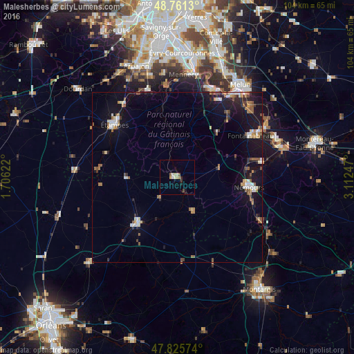
Analysis of Malesherbes night lights 2016
Square area 10x10 km:
 0.6%
0.6%90-99
1.64%80-89
0.89%70-79
1.19%60-69
0.45%50-59
0.89%40-49
0.89%30-39
1.04%20-29
0.3%10-19
1.34%0-9
90.77%Square area 50x50 km:
0.69%90-99
0.81%80-89
0.51%70-79
0.59%60-69
0.82%50-59
0.93%40-49
0.63%30-39
0.52%20-29
1.14%10-19
6.26%0-9
87.1%Clear (daylight) street map image can be seen on geolist.org.
Map coordinates:
48° 45' 40.7" North, 1° 42' 22.4" East
48° 17' 44.4" North, 2° 24' 33.7" East
47° 49' 32.7" North, 3° 6' 44.9" East
Some cities around Malesherbes sort by population:
• Étampes
23.9 km =14.9 mi,  310°
310°
• Fontainebleau
25 km =15.5 mi,  59°
59°
• Avon
25.8 km =16 mi, 62°
• Nemours
20.9 km =13 mi,  96°
96°
• Pithiviers
18 km =11.2 mi,  220°
220°
• Ballancourt-sur-Essonne
25.6 km =15.9 mi,  356°
356°
• Saint-Pierre-lès-Nemours
20.2 km =12.6 mi, 98°
• Itteville
24.9 km =15.5 mi,  348°
348°
2996444 (p: 6,335)
Sources (retrieved 2019-11-25):
» Earth at Night: Flat Maps 2012, 2016