Ballancourt-sur-Essonne night lights from space
Night Light of Ballancourt-sur-Essonne (Île-de-France) from space (France) Src. Average luminocity for 10x10km area is 11.9943% and for 50x50km: 31.1226%.
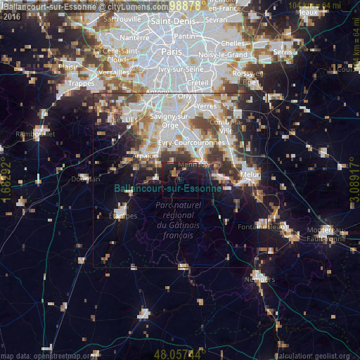
Analysis of Ballancourt-sur-Essonne night lights 2016
Square area 10x10 km:
 0.14%
0.14%90-99
0.28%80-89
0.57%70-79
1.28%60-69
3.13%50-59
0.85%40-49
0.43%30-39
2.27%20-29
10.23%10-19
19.46%0-9
61.36%Square area 50x50 km:
8.32%90-99
7.84%80-89
2.63%70-79
3.04%60-69
3.52%50-59
2.95%40-49
3.93%30-39
4%20-29
5.79%10-19
10.44%0-9
47.54%Clear (daylight) street map image can be seen on geolist.org.
Map coordinates:
48° 59' 19.6" North, 1° 40' 58.5" East
48° 31' 30.9" North, 2° 23' 9.7" East
48° 3' 26.8" North, 3° 5' 21" East
Some cities around Ballancourt-sur-Essonne sort by population:
• Brétigny-sur-Orge
11.2 km =7 mi,  328°
328°
• Courcouronnes
10 km =6.2 mi,  9°
9°
• Mennecy
6.5 km =4 mi,  41°
41°
• Saint-Fargeau-Ponthierry
11.1 km =6.9 mi,  71°
71°
• Bondoufle
9.8 km =6.1 mi,  356°
356°
• Lisses
9 km =5.6 mi,  17°
17°
• Itteville
3.3 km =2.1 mi,  250°
250°
• Villabé
8.6 km =5.3 mi,  33°
33°
3035228 (p: 7,001)
Sources (retrieved 2019-11-25):
» Earth at Night: Flat Maps 2012, 2016