Pithiviers night lights from space
Night Light of Pithiviers (Centre) from space (France) Src. Average luminocity for 10x10km area is 11.3929% and for 50x50km: 2.3129%.
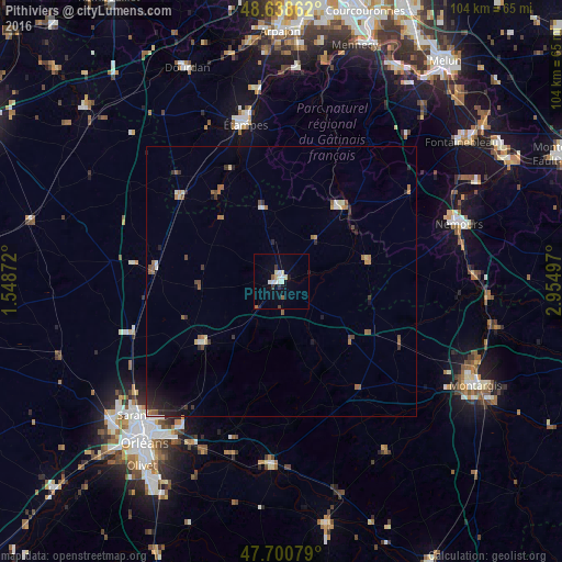
Analysis of Pithiviers night lights 2016
Square area 10x10 km:
 1.64%
1.64%90-99
3.72%80-89
1.19%70-79
0.6%60-69
0%50-59
1.49%40-49
0.3%30-39
1.49%20-29
0.6%10-19
1.79%0-9
87.2%Square area 50x50 km:
0.18%90-99
0.29%80-89
0.24%70-79
0.18%60-69
0.39%50-59
0.51%40-49
0.27%30-39
0.44%20-29
0.56%10-19
0.88%0-9
96.07%Clear (daylight) street map image can be seen on geolist.org.
Map coordinates:
48° 38' 19" North, 1° 32' 55.4" East
48° 10' 18.7" North, 2° 15' 6.7" East
47° 42' 2.8" North, 2° 57' 17.9" East
Some cities around Pithiviers sort by population:
• Étampes
30 km =18.6 mi,  347°
347°
• Saint-Jean-de-Braye
35.3 km =21.9 mi,  215°
215°
• Nemours
34.5 km =21.4 mi,  70°
70°
• Chécy
35.3 km =21.9 mi,  208°
208°
• Châteauneuf-sur-Loire
34.1 km =21.2 mi,  184°
184°
• Saint-Pierre-lès-Nemours
33.4 km =20.8 mi, 71°
• Malesherbes
18 km =11.2 mi,  40°
40°
• Souppes-sur-Loing
35.9 km =22.3 mi,  88°
88°
2987003 (p: 9,659)
Sources (retrieved 2019-11-25):
» Earth at Night: Flat Maps 2012, 2016