Fontainebleau night lights from space
Night Light of Fontainebleau (Île-de-France) from space (France) Src. Average luminocity for 10x10km area is 22.1776% and for 50x50km: 14.4335%.
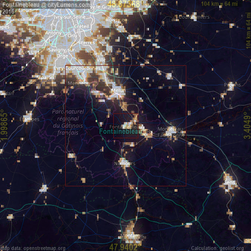
Analysis of Fontainebleau night lights 2016
Square area 10x10 km:
 1.85%
1.85%90-99
2.7%80-89
2.27%70-79
3.84%60-69
3.69%50-59
4.12%40-49
0.85%30-39
0.57%20-29
0.14%10-19
43.47%0-9
36.51%Square area 50x50 km:
2.62%90-99
2.88%80-89
0.96%70-79
1.63%60-69
1.65%50-59
1.77%40-49
1.52%30-39
2.69%20-29
3.2%10-19
9.98%0-9
71.1%Clear (daylight) street map image can be seen on geolist.org.
Map coordinates:
48° 52' 25.2" North, 1° 59' 55.1" East
48° 24' 32.7" North, 2° 42' 6.4" East
47° 56' 24.7" North, 3° 24' 17.6" East
Some cities around Fontainebleau sort by population:
• Le Mée-sur-Seine
14.7 km =9.1 mi,  338°
338°
• Dammarie-les-Lys
12.6 km =7.8 mi, 342°
• Avon
1.6 km =1 mi,  119°
119°
• Nemours
14.9 km =9.3 mi,  183°
183°
• Vaux-le-Pénil
13.2 km =8.2 mi,  356°
356°
• Champagne-sur-Seine
7.2 km =4.5 mi,  99°
99°
• Bois-le-Roi
7.2 km =4.5 mi,  1°
1°
• Veneux-les-Sablons
7.7 km =4.8 mi, 116°
3018074 (p: 19,717)
Sources (retrieved 2019-11-25):
» Earth at Night: Flat Maps 2012, 2016