Paray-le-Monial night lights from space
Night Light of Paray-le-Monial (Bourgogne-Franche-Comté) from space (France) Src. Average luminocity for 10x10km area is 9.872% and for 50x50km: 1.7802%.
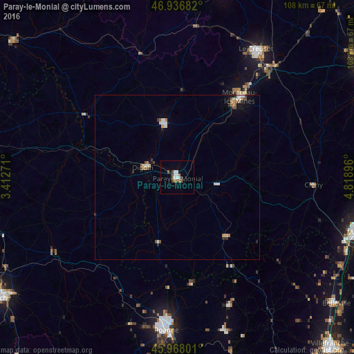
Analysis of Paray-le-Monial night lights 2016
Square area 10x10 km:
 2.38%
2.38%90-99
1.79%80-89
0%70-79
0%60-69
2.38%50-59
1.34%40-49
1.34%30-39
1.49%20-29
0%10-19
0%0-9
89.29%Square area 50x50 km:
0.24%90-99
0.35%80-89
0.14%70-79
0.13%60-69
0.31%50-59
0.24%40-49
0.27%30-39
0.19%20-29
0.16%10-19
0.48%0-9
97.49%Clear (daylight) street map image can be seen on geolist.org.
Map coordinates:
46° 56' 12.6" North, 3° 24' 45.8" East
46° 27' 16.5" North, 4° 6' 57" East
45° 58' 4.8" North, 4° 49' 8.3" East
Some cities around Paray-le-Monial sort by population:
• Saint-Leu
42.5 km =26.4 mi,  43°
43°
• Montceau-les-Mines
30.4 km =18.9 mi, 39°
• Saint-François
16.7 km =10.4 mi,  254°
254°
• Saint-Vallier
28.5 km =17.7 mi, 43°
• Digoin
10.9 km =6.8 mi,  285°
285°
• Gueugnon
17.1 km =10.6 mi,  346°
346°
• Blanzy
34.3 km =21.3 mi, 37°
• Bourbon-Lancy
32.4 km =20.1 mi,  305°
305°
2988592 (p: 9,840)
Sources (retrieved 2019-11-25):
» Earth at Night: Flat Maps 2012, 2016