Mazingarbe night lights from space
Night Light of Mazingarbe (Hauts-de-France) from space (France) Src. Average luminocity for 10x10km area is 74.4804% and for 50x50km: 37.4138%.
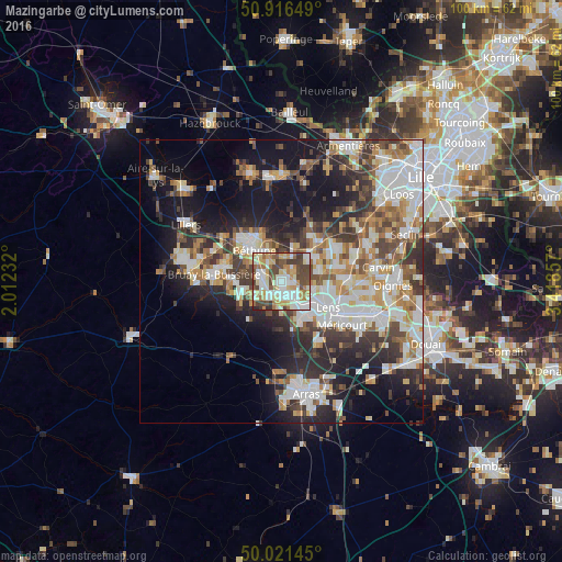
Analysis of Mazingarbe night lights 2016
Square area 10x10 km:
 15.69%
90-99
23.39%80-89
11.34%70-79
10.64%60-69
8.12%50-59
6.58%40-49
16.53%30-39
7%20-29
0.7%10-19
0%0-9
0%Square area 50x50 km:
8.45%90-99
8.63%80-89
3.57%70-79
4.13%60-69
4.53%50-59
4.25%40-49
5.11%30-39
5.98%20-29
8.82%10-19
15.35%0-9
31.18%Clear (daylight) street map image can be seen on geolist.org.
Map coordinates:
50° 54' 59.4" North, 2° 0' 44.4" East
50° 28' 15.9" North, 2° 42' 55.6" East
50° 1' 17.2" North, 3° 25' 6.9" East
Some cities around Mazingarbe sort by population:
• Bully-les-Mines
3.1 km =1.9 mi,  164°
164°
• Nœux-les-Mines
3.7 km =2.3 mi,  291°
291°
• Beuvry
5.5 km =3.4 mi,  337°
337°
• Barlin
7.1 km =4.4 mi,  252°
252°
• Loos-en-Gohelle
5.6 km =3.5 mi,  105°
105°
• Hersin-Coupigny
5.3 km =3.3 mi,  241°
241°
• Grenay
3.5 km =2.2 mi,  132°
132°
• Sains-en-Gohelle
3.7 km =2.3 mi,  218°
218°
2994837 (p: 7,587)
Sources (retrieved 2019-11-25):
» Earth at Night: Flat Maps 2012, 2016