Lambersart night lights from space
Night Light of Lambersart (Hauts-de-France) from space (France) Src. Average luminocity for 10x10km area is 93.0816% and for 50x50km: 48.7032%.
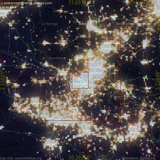

Analysis of Lambersart night lights 2016
Square area 10x10 km:
 58.29%
90-99
23.8%80-89
3.48%70-79
3.74%60-69
3.48%50-59
3.48%40-49
2.14%30-39
1.6%20-29
0%10-19
0%0-9
0%Square area 50x50 km:
12.33%90-99
9.98%80-89
4.24%70-79
6.01%60-69
6.57%50-59
6.64%40-49
6.97%30-39
6.67%20-29
9.99%10-19
16.68%0-9
13.92%Clear (daylight) street map image can be seen on geolist.org.
Map coordinates:
51° 5' 37.4" North, 2° 19' 48.8" East
50° 39' 0" North, 3° 1' 60" East
50° 12' 7.4" North, 3° 44' 11.3" East
Some cities around Lambersart sort by population:
• Lille
2.6 km =1.6 mi,  136°
136°
• Marcq-en-Barœul
4 km =2.5 mi,  62°
62°
• Lomme
3.3 km =2.1 mi,  257°
257°
• La Madeleine
3 km =1.9 mi,  98°
98°
• Loos
4.6 km =2.9 mi,  192°
192°
• Saint-André-lez-Lille
2.2 km =1.4 mi,  32°
32°
• Marquette-lez-Lille
3.7 km =2.3 mi,  38°
38°
• Wambrechies
3.8 km =2.4 mi,  15°
15°
3008218 (p: 28,613)
Sources (retrieved 2019-11-25):
» Earth at Night: Flat Maps 2012, 2016