Libercourt night lights from space
Night Light of Libercourt (Hauts-de-France) from space (France) Src. Average luminocity for 10x10km area is 64.521% and for 50x50km: 49.6243%.
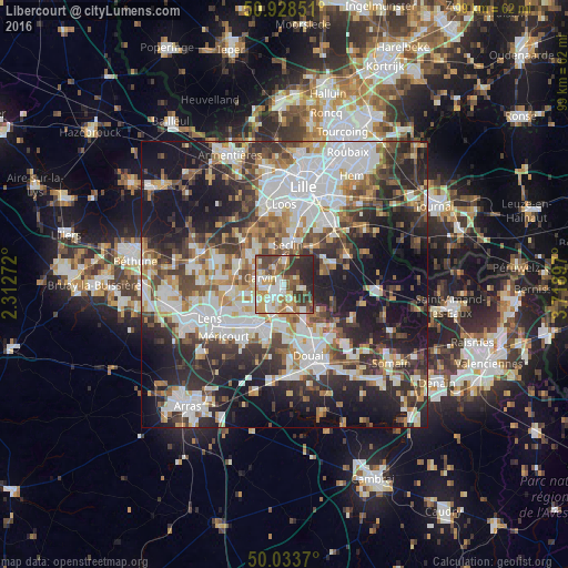
Analysis of Libercourt night lights 2016
Square area 10x10 km:
 14.15%
90-99
14.99%80-89
4.9%70-79
12.18%60-69
9.52%50-59
9.1%40-49
9.66%30-39
11.76%20-29
13.59%10-19
0.14%0-9
0%Square area 50x50 km:
12.74%90-99
10.7%80-89
4.22%70-79
5.08%60-69
5.96%50-59
5.77%40-49
6.96%30-39
7.94%20-29
13.42%10-19
18.85%0-9
8.36%Clear (daylight) street map image can be seen on geolist.org.
Map coordinates:
50° 55' 42.6" North, 2° 18' 45.8" East
50° 28' 59.6" North, 3° 0' 57" East
50° 2' 1.3" North, 3° 43' 8.3" East
Some cities around Libercourt sort by population:
• Carvin
4.2 km =2.6 mi,  283°
283°
• Seclin
7.3 km =4.5 mi,  6°
6°
• Oignies
2.7 km =1.7 mi,  215°
215°
• Courrières
5.7 km =3.5 mi,  239°
239°
• Leforest
6 km =3.7 mi,  145°
145°
• Courcelles-lès-Lens
7.4 km =4.6 mi,  179°
179°
• Dourges
5.6 km =3.5 mi,  202°
202°
• Ostricourt
3.8 km =2.4 mi,  159°
159°
2998520 (p: 8,443)
Sources (retrieved 2019-11-25):
» Earth at Night: Flat Maps 2012, 2016