Seclin night lights from space
Night Light of Seclin (Hauts-de-France) from space (France) Src. Average luminocity for 10x10km area is 61.8168% and for 50x50km: 51.673%.
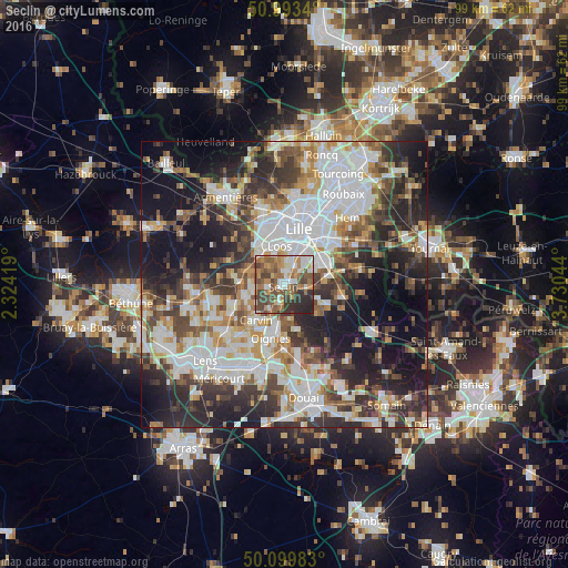
Analysis of Seclin night lights 2016
Square area 10x10 km:
 9.76%
9.76%90-99
11.9%80-89
3.34%70-79
8.69%60-69
16.71%50-59
15.11%40-49
15.37%30-39
8.69%20-29
10.29%10-19
0.13%0-9
0%Square area 50x50 km:
13.59%90-99
11.26%80-89
4.3%70-79
5.47%60-69
6.23%50-59
6.18%40-49
7.25%30-39
8.44%20-29
12.96%10-19
17.22%0-9
7.08%Clear (daylight) street map image can be seen on geolist.org.
Map coordinates:
50° 59' 36.2" North, 2° 19' 27.1" East
50° 32' 55.4" North, 3° 1' 38.3" East
50° 5' 59.4" North, 3° 43' 49.6" East
Some cities around Seclin sort by population:
• Loos
6.8 km =4.2 mi,  354°
354°
• Ronchin
7.1 km =4.4 mi,  38°
38°
• Faches-Thumesnil
4.7 km =2.9 mi, 35°
• Haubourdin
7.1 km =4.4 mi,  339°
339°
• Wattignies
4.3 km =2.7 mi,  15°
15°
• Annoeullin
7.1 km =4.4 mi,  252°
252°
• Wavrin
7 km =4.3 mi,  293°
293°
• Santes
6.7 km =4.2 mi,  317°
317°
2975361 (p: 12,214)
Sources (retrieved 2019-11-25):
» Earth at Night: Flat Maps 2012, 2016