Leforest night lights from space
Night Light of Leforest (Hauts-de-France) from space (France) Src. Average luminocity for 10x10km area is 67.3165% and for 50x50km: 45.3897%.
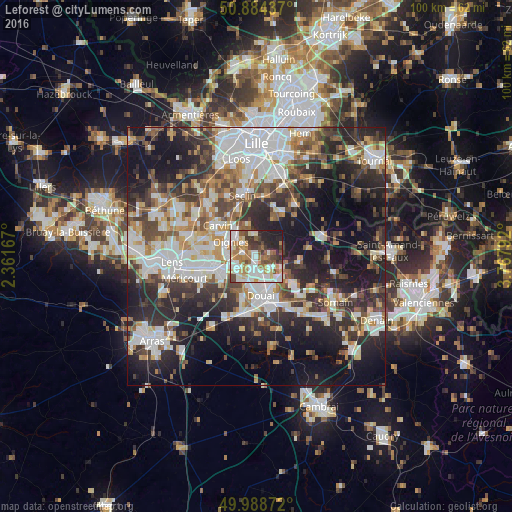
Analysis of Leforest night lights 2016
Square area 10x10 km:
 15.69%
90-99
19.47%80-89
6.86%70-79
6.02%60-69
13.73%50-59
7.14%40-49
8.96%30-39
7.56%20-29
10.78%10-19
3.78%0-9
0%Square area 50x50 km:
10.49%90-99
9.95%80-89
3.79%70-79
4.6%60-69
5.54%50-59
5.19%40-49
6.61%30-39
7.46%20-29
13.93%10-19
19.16%0-9
13.28%Clear (daylight) street map image can be seen on geolist.org.
Map coordinates:
50° 53' 3.7" North, 2° 21' 42" East
50° 26' 19.2" North, 3° 3' 53.3" East
49° 59' 19.4" North, 3° 46' 4.5" East
Some cities around Leforest sort by population:
• Oignies
5.7 km =3.5 mi,  298°
298°
• Auby
2.8 km =1.7 mi,  195°
195°
• Courcelles-lès-Lens
4.2 km =2.6 mi,  234°
234°
• Roost-Warendin
3.5 km =2.2 mi,  128°
128°
• Dourges
5.6 km =3.5 mi,  267°
267°
• Flers-en-Escrebieux
4.5 km =2.8 mi,  183°
183°
• Noyelles-Godault
5.6 km =3.5 mi,  245°
245°
• Ostricourt
2.6 km =1.6 mi, 303°
3004213 (p: 6,843)
Sources (retrieved 2019-11-25):
» Earth at Night: Flat Maps 2012, 2016