Clermont night lights from space
Night Light of Clermont (Hauts-de-France) from space (France) Src. Average luminocity for 10x10km area is 25.9572% and for 50x50km: 13.5534%.
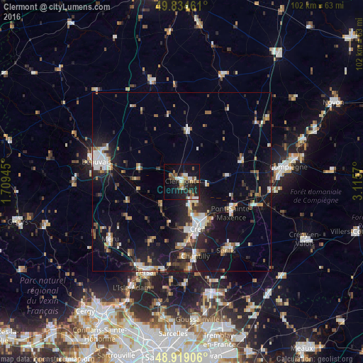
Analysis of Clermont night lights 2016
Square area 10x10 km:
 2.27%
2.27%90-99
5.35%80-89
1.07%70-79
3.74%60-69
3.21%50-59
4.01%40-49
4.14%30-39
3.21%20-29
8.42%10-19
28.74%0-9
35.83%Square area 50x50 km:
2.15%90-99
2.25%80-89
0.93%70-79
1.19%60-69
1.47%50-59
1.55%40-49
1.76%30-39
1.83%20-29
4.06%10-19
11.48%0-9
71.35%Clear (daylight) street map image can be seen on geolist.org.
Map coordinates:
49° 50' 4.6" North, 1° 42' 34" East
49° 22' 44.3" North, 2° 24' 45.3" East
48° 55' 8.6" North, 3° 6' 56.5" East
Some cities around Clermont sort by population:
• Creil
14.6 km =9.1 mi,  158°
158°
• Nogent-sur-Oise
12.7 km =7.9 mi, 160°
• Pont-Sainte-Maxence
16.4 km =10.2 mi,  121°
121°
• Montataire
13.5 km =8.4 mi,  172°
172°
• Liancourt
6.6 km =4.1 mi,  144°
144°
• Villers-Saint-Paul
11.5 km =7.1 mi,  150°
150°
• Saint-Just-en-Chaussée
14.1 km =8.8 mi,  5°
5°
• Mouy
9.8 km =6.1 mi,  223°
223°
3024643 (p: 11,025)
Sources (retrieved 2019-11-25):
» Earth at Night: Flat Maps 2012, 2016