Roost-Warendin night lights from space
Night Light of Roost-Warendin (Hauts-de-France) from space (France) Src. Average luminocity for 10x10km area is 65.1905% and for 50x50km: 43.4842%.
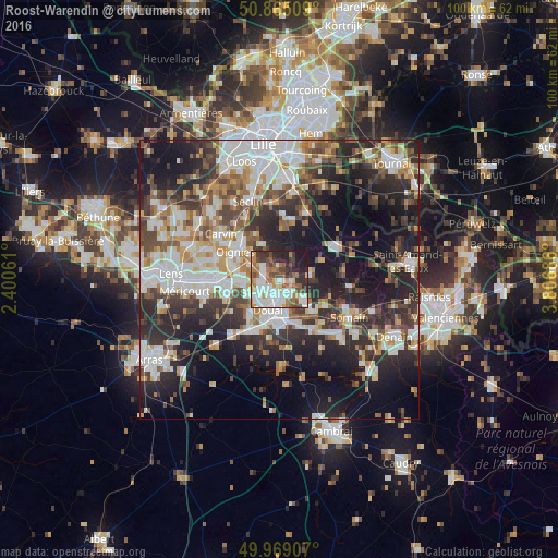
Analysis of Roost-Warendin night lights 2016
Square area 10x10 km:
 16.95%
90-99
18.49%80-89
4.48%70-79
5.6%60-69
11.48%50-59
7.56%40-49
9.52%30-39
8.26%20-29
11.9%10-19
5.74%0-9
0%Square area 50x50 km:
9.46%90-99
9.63%80-89
3.64%70-79
4.29%60-69
5.5%50-59
5.12%40-49
6.38%30-39
7.48%20-29
13.74%10-19
18.54%0-9
16.21%Clear (daylight) street map image can be seen on geolist.org.
Map coordinates:
50° 51' 54.3" North, 2° 24' 2.2" East
50° 25' 9.1" North, 3° 6' 13.5" East
49° 58' 8.7" North, 3° 48' 24.7" East
Some cities around Roost-Warendin sort by population:
• Douai
5.7 km =3.5 mi,  197°
197°
• Waziers
3.6 km =2.2 mi,  167°
167°
• Auby
3.6 km =2.2 mi,  261°
261°
• Cuincy
5.7 km =3.5 mi,  219°
219°
• Leforest
3.5 km =2.2 mi,  308°
308°
• Lallaing
5.7 km =3.5 mi,  124°
124°
• Flers-en-Escrebieux
3.9 km =2.4 mi,  232°
232°
• Flines-lez-Raches
5.6 km =3.5 mi,  92°
92°
2982890 (p: 5,875)
Sources (retrieved 2019-11-25):
» Earth at Night: Flat Maps 2012, 2016