Le Péage-de-Roussillon night lights from space
Night Light of Le Péage-de-Roussillon (Auvergne-Rhône-Alpes) from space (France) Src. Average luminocity for 10x10km area is 38.3635% and for 50x50km: 10.9285%.
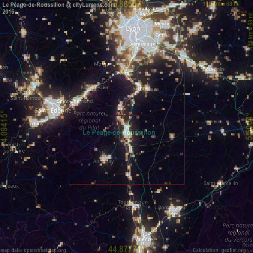
Analysis of Le Péage-de-Roussillon night lights 2016
Square area 10x10 km:
 6.03%
6.03%90-99
8.73%80-89
4.92%70-79
3.02%60-69
3.81%50-59
2.86%40-49
3.49%30-39
6.51%20-29
17.14%10-19
35.4%0-9
8.1%Square area 50x50 km:
1.13%90-99
1.78%80-89
0.84%70-79
1.13%60-69
1.29%50-59
1.35%40-49
1.77%30-39
1.42%20-29
3.36%10-19
11.75%0-9
74.18%Clear (daylight) street map image can be seen on geolist.org.
Map coordinates:
45° 51' 56.1" North, 4° 5' 38.9" East
45° 22' 25.7" North, 4° 47' 50.2" East
44° 52' 39.8" North, 5° 30' 1.4" East
Some cities around Le Péage-de-Roussillon sort by population:
• Vienne
17.9 km =11.1 mi,  19°
19°
• Annonay
17.9 km =11.1 mi,  213°
213°
• Givors
24.2 km =15 mi,  354°
354°
• Rive-de-Gier
22.2 km =13.8 mi,  320°
320°
• Roussillon
1.4 km =0.9 mi,  89°
89°
• Pont-Évêque
19.7 km =12.2 mi,  26°
26°
• Chasse-sur-Rhône
22.8 km =14.2 mi,  2°
2°
• La Grand-Croix
23.5 km =14.6 mi,  307°
307°
3002988 (p: 6,869)
Sources (retrieved 2019-11-25):
» Earth at Night: Flat Maps 2012, 2016