Rive-de-Gier night lights from space
Night Light of Rive-de-Gier (Auvergne-Rhône-Alpes) from space (France) Src. Average luminocity for 10x10km area is 24.5803% and for 50x50km: 23.7906%.
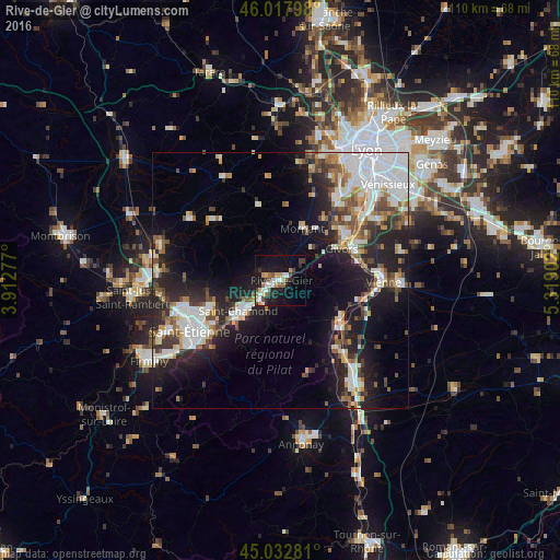
Analysis of Rive-de-Gier night lights 2016
Square area 10x10 km:
 3.48%
3.48%90-99
4.39%80-89
1.82%70-79
3.94%60-69
2.73%50-59
2.73%40-49
3.18%30-39
3.33%20-29
3.79%10-19
23.79%0-9
46.82%Square area 50x50 km:
5.62%90-99
5.18%80-89
1.66%70-79
2.06%60-69
2.59%50-59
2.93%40-49
2.93%30-39
2.88%20-29
6.88%10-19
13.61%0-9
53.65%Clear (daylight) street map image can be seen on geolist.org.
Map coordinates:
46° 1' 4.7" North, 3° 54' 46" East
45° 31' 39.2" North, 4° 36' 57.2" East
45° 1' 58.1" North, 5° 19' 8.5" East
Some cities around Rive-de-Gier sort by population:
• Saint-Chamond
9.9 km =6.2 mi,  234°
234°
• Givors
13.8 km =8.6 mi,  59°
59°
• Sorbiers
14.2 km =8.8 mi,  253°
253°
• La Talaudière
15.9 km =9.9 mi, 248°
• Saint-Jean-Bonnefonds
15.7 km =9.8 mi,  239°
239°
• Chasse-sur-Rhône
16.1 km =10 mi,  69°
69°
• Mornant
11.1 km =6.9 mi,  23°
23°
• La Grand-Croix
5.1 km =3.2 mi, 239°
2983408 (p: 14,852)
Sources (retrieved 2019-11-25):
» Earth at Night: Flat Maps 2012, 2016