La Grand-Croix night lights from space
Night Light of La Grand-Croix (Auvergne-Rhône-Alpes) from space (France) Src. Average luminocity for 10x10km area is 37.1952% and for 50x50km: 21.9391%.
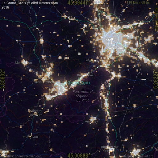
Analysis of La Grand-Croix night lights 2016
Square area 10x10 km:
 8.25%
8.25%90-99
8.25%80-89
2.54%70-79
4.44%60-69
4.13%50-59
3.97%40-49
3.65%30-39
2.22%20-29
5.87%10-19
41.59%0-9
15.08%Square area 50x50 km:
4.02%90-99
4.55%80-89
1.91%70-79
2.03%60-69
2.53%50-59
2.7%40-49
2.95%30-39
2.72%20-29
7.55%10-19
14.66%0-9
54.39%Clear (daylight) street map image can be seen on geolist.org.
Map coordinates:
45° 59' 40.1" North, 3° 51' 21.7" East
45° 30' 13.8" North, 4° 33' 32.9" East
45° 0' 32" North, 5° 15' 44.2" East
Some cities around La Grand-Croix sort by population:
• Saint-Étienne
15.3 km =9.5 mi,  239°
239°
• Saint-Chamond
4.8 km =3 mi,  229°
229°
• Rive-de-Gier
5.1 km =3.2 mi,  59°
59°
• Sorbiers
9.3 km =5.8 mi,  261°
261°
• La Talaudière
10.8 km =6.7 mi,  253°
253°
• Saint-Jean-Bonnefonds
10.5 km =6.5 mi, 239°
• Saint-Priest-en-Jarez
14.6 km =9.1 mi, 256°
• Mornant
15.5 km =9.6 mi,  34°
34°
3009015 (p: 5,045)
Sources (retrieved 2019-11-25):
» Earth at Night: Flat Maps 2012, 2016