Le Mesnil-le-Roi night lights from space
Night Light of Le Mesnil-le-Roi (Île-de-France) from space (France) Src. Average luminocity for 10x10km area is 81.9233% and for 50x50km: 59.156%.
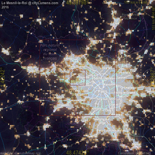
Analysis of Le Mesnil-le-Roi night lights 2016
Square area 10x10 km:
 27.98%
90-99
25.14%80-89
8.66%70-79
7.81%60-69
7.24%50-59
10.51%40-49
12.64%30-39
0%20-29
0%10-19
0%0-9
0%Square area 50x50 km:
25.62%90-99
13.52%80-89
4.45%70-79
4.02%60-69
4.94%50-59
4.3%40-49
5.37%30-39
4.91%20-29
7.85%10-19
12.12%0-9
12.9%Clear (daylight) street map image can be seen on geolist.org.
Map coordinates:
49° 23' 52.7" North, 1° 25' 20.7" East
48° 56' 17.7" North, 2° 7' 31.9" East
48° 28' 27.3" North, 2° 49' 43.2" East
Some cities around Le Mesnil-le-Roi sort by population:
• Sartrouville
5 km =3.1 mi,  77°
77°
• Houilles
5.2 km =3.2 mi,  110°
110°
• Maisons-Laffitte
2.2 km =1.4 mi,  41°
41°
• Achères
4.9 km =3 mi,  301°
301°
• Le Vésinet
5.1 km =3.2 mi,  173°
173°
• Le Pecq
5.3 km =3.3 mi,  197°
197°
• Montesson
3.3 km =2.1 mi,  164°
164°
• Carrières-sur-Seine
5.2 km =3.2 mi,  131°
131°
3003375 (p: 6,515)
Sources (retrieved 2019-11-25):
» Earth at Night: Flat Maps 2012, 2016